Salt Spring Island Archives


| Accession Number | a presentation to the Historical Society at Central Hall | ||
| Date | September 12, 2018 | ||
| Media | digital recording | Audio | mp3 √ |
| ID | duration | 75min |
 sshssept.001.jpg
 sshssept.002.jpg
 sshssept.003.jpg
 sshssept.004.jpg
 sshssept.005.jpg
 sshssept.006.jpg
 sshssept.007.jpg
 sshssept.008.jpg
 sshssept.009.jpg
 sshssept.010.jpg
 sshssept.011.jpg
 sshssept.012.jpg
 sshssept.013.jpg
 sshssept.014.jpg
 sshssept.015.jpg
 sshssept.016.jpg
 sshssept.017.jpg
 sshssept.018.jpg
 sshssept.019.jpg
 sshssept.020.jpg
 sshssept.021.jpg
 sshssept.022.jpg
 sshssept.023.jpg
 sshssept.024.jpg
 sshssept.025.jpg
 sshssept.026.jpg
 sshssept.027.jpg
 sshssept.028.jpg
 sshssept.029.jpg
 sshssept.030.jpg
 sshssept.031.jpg
 sshssept.032.jpg
 sshssept.033.jpg
 sshssept.034.jpg
 sshssept.035.jpg
 sshssept.036.jpg
 sshssept.037.jpg
 sshssept.038.jpg
 sshssept.039.jpg
 sshssept.040.jpg
 sshssept.041.jpg
 sshssept.042.jpg
 sshssept.043.jpg
 sshssept.044.jpg
 sshssept.045.jpg
 sshssept.046.jpg
 sshssept.047.jpg
 sshssept.048.jpg
 sshssept.049.jpg
 sshssept.050.jpg
 sshssept.051.jpg
 sshssept.052.jpg
 sshssept.053.jpg
 sshssept.054.jpg
 sshssept.055.jpg
 sshssept.056.jpg
 sshssept.057.jpg
 sshssept.058.jpg
Arnett_Overland-Indigenous-Canoe-Travel.mp3
otter.ai
24.04.2023
no
Speaker 1 0:00
One of the panels is going in on Atkins road. And it's going to be reflective of the use of the small creek in that area for the First Nations groups to use as a portage Creek and Chris Arnett, who has worked with us in the past before has researched and studied this. And Chris has agreed to come here today. And tell us what he's found out. And you can see the start of it on the screen now. So Chris, welcome to historical society.
Speaker 2 0:39
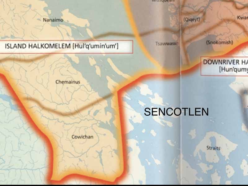
It's great to be here. Thanks for coming. Yeah, so to the title of my talk is what state lemon in place of the third polls, indigenous Overland? Can you travel on Saltspring island, so always think of people in canoes traveling in the water. But sometimes you have to go overland to save yourself a bit of paddling. Hey, worse, to stay tuned. You'll learn everything. Again, oh, the name Yeah, quit say a month, click sick the man. Now say the man is a purple, an immature for three with the barkston peeled off it. And then it's been scorched a bit with fire. And then used as a pole that you roll things over. So this is what they did in a lot of places they would, you know, wanted to take a canoe overland, you would gather a bunch of these for trees, preparing this way strip the bark, char them and lay them down like a corduroy Road in areas where you know, there was a bit of height of land or something, then you pull it with ropes. But they only did this in places where you know, it was a height of land or something inlet places, they didn't have to use these things because they could use creeks and waterways or the or the land was level. Then anyway, I'm going to talk about this place. And what site lemon is a place name, you won't find it on a lot of maps. I learned it from an elder years ago, and it was published on a map of tremendous First Nations place names and the name author refers to the the head of this canal in Boothbay, so it may or may have referred to a village site. When you see that, the prefect qua the beginning of that what say amen. Hawk means like a place place up for pole. So it may have named a village place, it may have referred to a portion of this canoe route. There's a bunch of names around here that I'm going to talk about. We're not still sure exactly where these names were they actually for to general, this name was used for parts of this overland canoe route. And I first learned about this, this shows you the value of oral histories and traditions so years ago. Well, yeah, the latter part of the 20th century. I was interviewing elders in different communities about this you Saltspring Island, and I met two gentlemen from Connecticut Island, which is the island north of us used to be called keeper Island. And they told me about this canoe skid, you know, we're talking to place things and I said, just one guy, Henry Edwards. And the other guy was Roy Edwards. Your two brothers are born at UCLA multi Bay on phenolic. Island. So it's asking about place names, names. And so all of a sudden he brought this up out of the blue, he said when they can, when they're in a hurry. They go to that Bay across from Crofton, Boothbay. They drag their canoe right over the Ganges, they had skids. That little creek goes right into Ganges, it takes them about two hours. And they're going in that shelf, which was the name of Ganges, instead of going around the island, which would take five or six hours. Rowing, rowing to that bunch, or wherever it is walkers hook, and then the camp, they will have a lot but anyway, but if they can go through the canal, they're they're taken to ours and they're already at Scheldt. They would just drag the canoes in the canal there and taken about two hours. And they're already a show. They would just drag their canoes on that creek in the 30s. I could see them skids in the little creek, the Hudson lemon Farah, and they got scared of the white people. And I turned back there was nothing but white people all over close to that Canal where the Indians used to drag their canoes. So I saw some so you went and have a look. This is in the 30s he did this. Yeah, just to look, you know, just to look to see how they did it there in the early days. They just take the shoes off and just walk or some of them would just walk right in the water there and drag their canoes right over the field there in two hours. And was there an Indian name for that canoe skit? Yes. No never heard shyness. That's a name that comes up here that little bay or the Indians used to pull their canoes right over the Ganges could be shyness would that can use get used by anybody, or was restricted to certain families. Anyone in our family, I guess, the ones that get over there, I know that there's a river that goes right to Ganges, they go there in a canoe and go over there. And the olden days, people from keeper Island. Yes. And then I asked him more about this and his brother. And they confirmed that this was a root. And it was off it was used throughout the year, but it's most often used during a great migration in in the summer, when a lot of villages a lot of people from Cowichan, from humaneness from halt from Connecticut, will use this route to go into Ganges on their way to the Fraser River for the great Sockeye fishery. So I'm going to talk about that a bit. So that's just the oral history. And, you know, archaeologists hadn't identified this, nobody else knew about it, but it shows you the value of oral histories. And the thing is, there's stories that are preserved in people's minds, and a lot, you know, some valuable stuff. So I really treasure it. I'm an archaeologist. But I'm also ethnographer. And I'm a historian. So I'm three in one, which I feel very privileged to have that sort of interdisciplinary approach, because you have to become an expert and level all of these things. Anyway, not that I am I'm working on. So Salt Spring Island, is the largest of the Gulf Islands had the largest pre contact populations. This is a map, little triangles refer to known archaeological sites on the island, the circles refer to known or to evidence of large village sites and look it in there, I think there's about 16 or so. So this island is very heavily populated up until about the 1780s. And there hasn't been a lot of archaeological work done here, which is kind of surprising, given the size of the island. But the little bit of work is done. We know that people have lived here for at least 4000 years, we have radiocarbon date from long harbor up there stop up in the upper right. Think that 4000 years, and I'll talk more about some radiocarbon dates as we go along. This just shows you there. You know, and these are the known sites, I mean, it could be twice as many sites that haven't been recorded. So what happened these people, I mean, the people were still around, of course, living in communities around Saltspring island. But we always got to bear in mind, you know, the great epidemic of 1782. And it began actually was a long process that began in Florida. 1511 was the first documented instance of smallpox in North America. And this is a map was put together by a fella named Tim Jones, where he based in a lot of ethnic historic records and shows he was able to plot the progression of the disease across in 50 year kind of intervals across the continent. And see it took a while for 1511 to hit our area, but you see a huge area there, between 1767 79 That was finally hit. And in the wake of this epidemic, and it's really hard to imagine, there were 90 up to 90% fatalities. So you can imagine safe place like Ganges in the course of a week, if nine out of 10 died, you can imagine the impact would have on the community. So you have to imagine that throughout this whole vast area. 10s of millions have perished in these epidemics. But so they didn't hit the West Coast until relatively late. And when they did, they came up through the Snake River, the Columbia River and then up into Puget Sound Gulf of Georgia. And that kind of petered out around Pete much Campbell River area. But the people in this area in Section 82. Like I said, nine out of 10 killed, and this is probably what really, you know, wiped out a lot of these villages on Saltspring island. But anyway, the people are incredibly resilient, incredibly resilient people. And their population began to grow after the collapse. And so when the non natives arrived here, the one Edom, we're the one Edom, people that came out of nowhere, how that word can translate. They think they encountered a lot of people living here, not as many as before, of course, and this is a map from the Solow Atlas is showing the different linguistic divisions, the people in this area speaking area, where we actually saw things a little complicated, you see Saltspring here, and Saltspring is right in the middle of sort of shares the linguistic Now, are these linguistic groups share? Saltspring, I guess?
Speaker 2 10:07
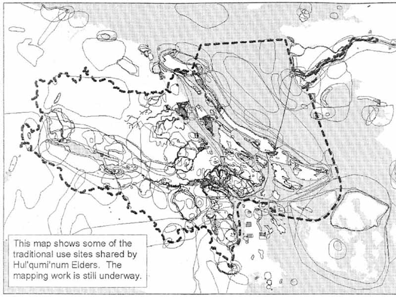
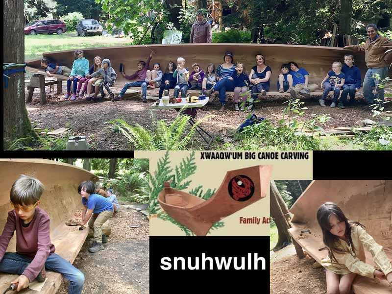
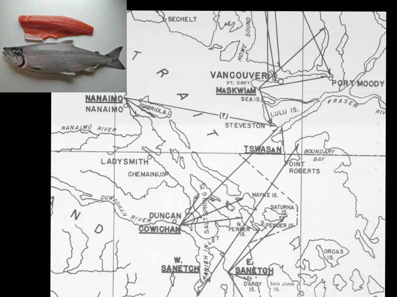
Let's see chilliness couch. And these are dialects of Helcom aylen, which is language spoke from East Vancouver Island all the way up to hope. But there's all kinds of regional dialects of haka meet him here, to me this example of Calico and slightly different. And when I used to interview elders, they would say that every village had its own kind of way of speaking, or speech, or even words. So very kind of complex culture. And, of course, people have been living here for upwards of 5000 years, probably longer. In fact, I'm sure quite a bit longer, maybe up to 9000 years. And they need to displace incidentally. So anyway, and here, we have said, Shortland, which is the language spoken by Saanich people in the streets Salish. And but, you know, these languages were, is different in French, as French and English, but people learned each other's languages. So there was a lot of, you know, exchanged back and forth, and a lot of the intermarriage and so on. And people by and large, lived a pretty friendly, peaceful life. There's always stuff that happened, but is resolved one way or another. But anyway, shows you some of the linguistic diversity here. But most of the north part of Saltspring Island was subcloned, and controlled by groups from Cowichan, and shininess, and Pelican Island. Here's the map I love to show, it's from the 90s, when a whole community group is, you know, gathering material for their for their land claims. And it shows you how the native people use the land. You know, it wasn't divided up into rectangles and things like that. There's all based on customer use of the land by people over millennia. And all of these little circles and things as shown here. Refer to interviews with elders, where the people just ask them, What did you gather over here? Where did you gather mushrooms? Where did you get the cedar bark? Where did you have this where you had that, where you fish this where the fish that, and this is based on you know, the scores of interviews. And you can see, they use all kinds of different parts of the territory in the land, not just in their immediate areas of the village sites. But even over on the as far on the other side of the Gulf of Georgia. There were migrations over there back and forth all the time, including a very big one, in the summer, months to fish, the sockeye, the Fraser River. Yes, and Salt Spring Island is right here. Seems heavily used all these little circles inland and on the coast refer to various food gathering activities. Because these were food producers and archaeologists are anthropologists, we like to call them hunter gatherers, which kind of gives us a sense of people wandering around, you know, here's some food, let's get it. But these people, you know, have long established, you know, customary rights and access to a wide range of area. And it was all negotiated through intermarriage and family alliances, and allowed for these large populations, because they knew how to make the best use of the resources is anyone would know if you've lived in a place for 1000s of years. And the intergenerational knowledge just teaches people about it. So how do people get around in those days? Well, probably about 5000 years ago, 4000 years ago, cedar started coming in to Cedar came in, just like people did. It wasn't always here. Cedar was introduced, you know, gradually from the south, I think around 6000 years ago. And as the trees began to grow, people began to figure out how to make these incredible laws, incredible trees into all kinds of valuable commodities. And one of the most valuable of which of product at the theater was the snow off, which is the canoe. And see, up at the top here three versions of the typical Coast Salish canoes, the sort of flat bottomed River canoe up there, another what they call the shovelnose canoe in the middle, which was used in a lot of the rivers and inland waters. And then finally this large seagoing canoe, which is sometimes called the chin up style. And it's based on a canoe that was used very popular in the West Coast, because you know, the West Coast a lot of surf. And so it was a canoes specially built to withstand open water. And there's one thing some of you may know. Joey Ackerman and his Hacohen group has been building one of these canoes on the island is the first one built here in well over a century. And it's one of these Chinook West Coast's canoes. It's been sort of modified in the Coast Salish style, and it's all finished. I believe launch Just this week sleigh. Okay, anyway, it's coming. It's gonna. And anyway, so it's a beautiful canoe. And it's really cool because they've evolved all kinds of community members in, in building it. And so it's a great teaching device and it was built by or supervised by Joe Martin over there in the upper right. Very well known can you make her from play a quick area play a quick sound near Tofino so beautiful project smells. So this is the end, you know, this is a great way it's no, it's just a traveling container, they use the same word for cars today going to go any car I'm gonna go my snow off. So just it's a vehicle but this is the, you know, this was the main transportation device and these canoes are all different sizes they could hold, you know, I've heard stories, some could hold it for 50 people, all different sizes for all different kinds of use, but enable these people to travel pretty well, anywhere. And here's just another shot of the canoe being finished up really quite a beautiful thing. So snow off. So the people usually snow off. And of course theater was used to build these incredible long houses, late Lem. And these are this is a photograph in 1868, of the village of Nixon over in the couch and river area. And it was one of the larger villages there. I think there are about 15 houses there. These are just three of the houses that you can show you these, this is a great shot because it shows you the construction of these huge houses that can house up to 100 people, all members of one extended family. And you can see how the houses are put together and built with over a framework of posts and beams. And then they have these sort of a double pools long size and they fit in giant boards to create the house. And the cool thing about this house is you can take it apart and take it with you and loaded on canoes, which is what these people did. And so most of the year they would live here, say equipment center or whatever village and then during the summer, they would dismantle these houses. This is right by the river. The river is right here in the foyer, this picture is taken from and they would get two of these large snowball canoes. And then they would just disassemble these houses and lay the plates on these double canoes and then take them over to the Fraser River. So probably take a few days the wait for the weather to be nice, but they basically take these over there and reassemble them at a famous fishing village that we'll talk about in a bit. It stopped in 1870 when British Columbia join Confederation and the Canadian Canadian government got involved and put a stop to this migration because they'd rather had because they began to establish tanneries up here and we live in the freezer, and they didn't want hundreds and maybe 1000s of couching coming over there and fishing. So kind of a little bit of nasty colonial history. And it's thought, anyway, this map, there's beautiful Sockeye and the sockeye was, you know, incredibly important fish not just for the people, the Fraser River we think of sockeye using the Fraser River, but it was it was a nexus for all of these groups. And this is a map that was produced in the 1950s by a ethnologist named Homer Barnett. He worked here and interviewed lots of elders and basically shows these you see these lines here he was interviewed people in these different villages like in couch and up in an IMO Savage, and ask them about their where they got food. And so they often refer to, you know, the local food production, but they also refer to this migration, where they went, zoot, right across the street, up to here and cesarean and Fraser River, south shore of Lulu Island, to fish, so it's a very important part of their economy. So you can imagine an ETF for 1870 when they were denied access to it, it created quite a bit of hardship for the people. Now people didn't just go over to the Delta. For fish, the Delta was also very important for all kinds of other things. They called it, still call it fun, Spot fun, which means a productive meadow, a productive meadow, so these are this refers to all of the incredible berries, the spagna moss, all kinds of plants, medicinal plants, food plants, cranberries, all these things are available and he's productive Meadows. This is a map of for project I did for Connecticut, on their traditional use of that area there see the village of Connecticut, which is just one of dozens of villages that accessed the mainland. Not just in the summer, like I said, but throughout the year whenever they could get across because you know, sometimes it's a little Clement, but they went back and forth quite regularly in the in Chenoa canoes. And
Speaker 2 20:09
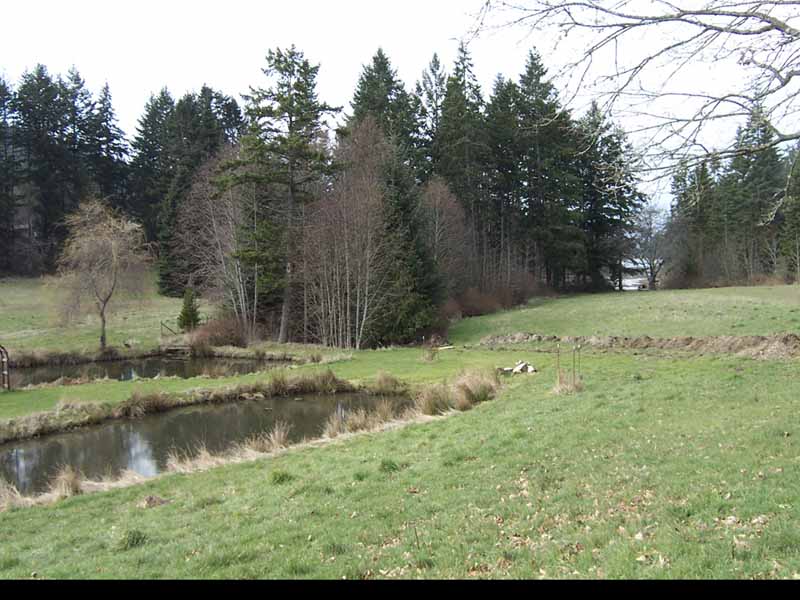
part of the evidence again, oral you're not a lot of archaeology has been done to verify this. We're not sure how long these migrations were going on. But these are hot can eat them. Thank you, Brian one place names apply to certain areas in the Delta area. We all did all kinds of like smart toilets. So often, Lawson, Alex, and so on. And this is what we're gonna look at flirtiness This is the most important, Paul hang them up. That's the George Massey tunnel, very important area as well. But it just shows, you know, this, this close connection that people had in the Gulf Islands to the mainland. Now this is all in dispute, because you know, couchtuner trying to get access to fisheries here and mainland, native bands are fighting it. So it's all this, you know, this fallout from the colonial period, pitching to fitting, you know, indigenous people against each other. Whereas in the past, they went back and forth quite freely, and everybody, you know, could benefit. So, we're just gonna look at flirtiness now. Now, this is a cool map. From 1827, and Hudson's Bay Company came here, they wanted to build a for trading depot. They're looking around for a place. They met a leader from baldies Island takea, a couch in a row for helping you to man. And he, he basically controls the whole sets arm of the Fraser. So it's interesting. People from this side control the south arm of the Fraser, and he took them over there and showed them the fort, the site of Fort Langley, and so you can build your fort here. It's kind of interesting. But anyway, so when the when the Hudson's Bay came in here, this is the first map they produced 1827 And you can see the senior couch and villages. And you see these, these three sort of big groups of houses double road. And this was a huge village. And this is fluoxetine, S, which just means Long Beach, because there was a long beach here. And now it's covered by buildings that are used by the Port of Vancouver. So very industrialized, you know, container, parking lots and all this stuff. It used to be the site of the Richmond dump. But in 1827, this village was two and a half miles long, and one guy started to count the houses, and he gave up at 100, Nate. So a lot of people here, and each. The interesting thing about this village is that it was divided into sections, according to where the people had originated. So people from Connecticut had their own section, people compartments and had their own section, people from Scotland, I had their own section and so on. So every group on Vancouver Island and went over here and brought their houses over. And then there were frameworks are already here, they would just take the planks off the canoes, rebuild their houses, and he would stay here for two months and fish, the sockeye and access, you know, the whole Fraser River, and they trade to that go way up and trade with the interior Salish people. So it was a very important area. And here's a map that was produced recently for the whole community or couch and tribes, showing the village of floatiness. And number houses, there's been a little bit of archaeological work down here. But like I said, the places covered by the Richmond, the old Richmond city dump, all this industrial stuff. So literally, the village is sitting under like a few meters of junk, and garbage. But if you go down along the water at low tide, you can see remnants of little fissures and things. And this map is sort of based on the very slim archaeological evidence. It's visible, but it's all there. It's just all underground. Does that map, Hudson's Bay map again, just showing where floatiness is when you go through the George Massey tunnel. It's about a kilometer and a half east, on the north side of the river. And that's flirtiness. And then up to your freezer up you can see I placed the crate, that's a another important site is right across from New Westminster, where people from the island also went and access the sockeye fishery. So lots of people going back and forth in canoes, from the islands to the mainland, to access as important fishery. So this place this is one of the sort of the the first sort of comprehensive maps of the Northwest Coast done by Walter Grant, who is Vancouver island's first independent settler, came here in 1849 1850. And he brought the broom so those of you who like broom and thank, Mr. Grant, and if you go to soup, and if you look at an aerial photograph of soup, it's just yellow with broom. There's this dense yellow and that kind of fill There's that but that's the that's the heartland of a broom is Sook. And that's her grant homestead. But anyway, Grant is a surveyor. And at 56, he produced this map of the Northwest coast, and doesn't show any native villages except one shows Latinas because it was like the metropolis, and you can't see it on this map. Here's a detail much nicer halogen villages See that little s. And it's interesting. I've looked at a lot of maps from this time period. And I've identified 14 maps that were made by different you know, explorers, visitors, Americans, Germans, and the only indigenous village shown and all of these maps are in the 19th century, all these 14 maps of sitting Northwest coast, are the villages here, because it's such an important place. You can imagine all of the villages of Vancouver Island, Southern Vancouver Island migrating over this place. And in the summer, when most of the non natives visited, you know, this was a huge I mean, some people even refer to it as a metropolis. That's the Delta. What's with us now it's in villages. The Delta area, right? Well, yep, no, this is referring to the village of cattiness and the other ones are all along here, but they access all this area. The Delta in those days was honeycombed with with canals and flus and things. And like I said, very, very rich in all kinds of bird life, you know, animals, plants, burns bog very important place. So when you click genus, yeah, phrases, which are almost extinct, I think, you know, people rarely see them. So now we're going to look focus here locally on this spot on the set off, which is see the word up at the top. You can see that word snowwolf, kind of buried in there. And when you study the HUD commune language, they have a lot of, we have suffixes and prefixes they have in fixes. So they put stuff in the middle of the word. So it's really hard to learn this language. I don't know it. I know a few words, I'll never be fluent. But I find it really valuable to study the language to you know, get a better understanding of places because these names, place names have a lot of information. And so he asked an elder arbitrarily the team about this canoe portaledge because I heard about it when I was interviewing other elders. And he said, Oh, yeah, that's a ship solos. And then there's the route, we can see how that word breaks down just suits something done with a tool, and then the action of dragging a canoe. So it's one of these languages that has a lot of Alma, I never get this word right on them for 480 words. Thank you. That's onomatopoeia. Where the the sound becomes the word and so you know, the dragon has to do a lot. And it wasn't a portage, they weren't carrying these things. Because, you know, these canoes weigh a time or two times, and especially when they're loaded with gear and stuff, so they would drag them along this route. And so the whole route, this was kind of any place where you drag the canoe overland would be called one of these things, shirts, ovals, which is something done, too. So that's, and this is this great picture. aerial photograph taken in 1930, approximately, showing the original town of Ganges what it looked like, prior to all the development, and this is the place of show cheok there's word and the village of shall occupy this state here, probably into this area, and then parts of it were up around where Howard harbor house was. And up there is quit sake lemon, which is a name that's often associated Boothbay and this canoe skid, and then this other word shyness, and no one knows what that word means. But they often use that China's to refer to someplace along this canoe Portage, and you can kind of see it here you can see that the hull of land is very low. And up, there's this canal and the skid sort of follow the path of least resistance along this route, and then came out down here, approximately where Ganges Creek is today. Still is.
Speaker 2 29:41
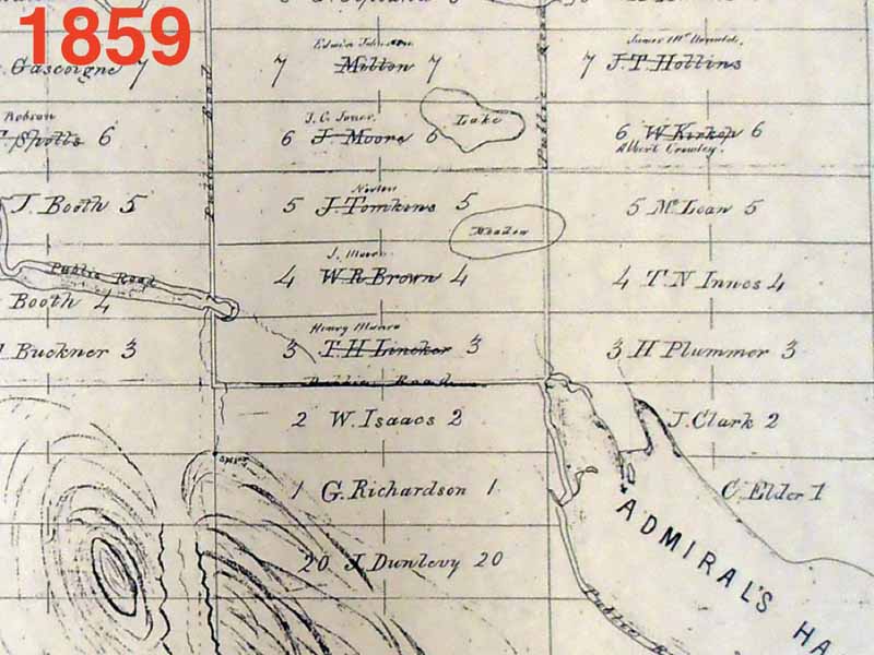
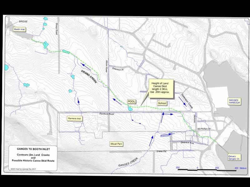
Anyway, this is I guess, last year, I was talking to Don clog about this and we decided we should you know, it'd be nice to find the route and so don produced this map, basically got a elevation map from islands trust. And then we just drew a line on the on the path of least resist That's, you know, if you're gonna drag a canoe or anything, or walk between the head of booth canal and Ganges Harbor, what would be the path of least resistance? So we came up with this, this rough map, which I think is probably very accurate, and then we later groundtruth it, and I'll show you some pictures of it. But it's interesting, we look back at this map, this is one of the first maybe the first detailed map of properties on Saltspring. Island preemptions. In 1859, showing all the different preemptions and the different early settlers. And there seems to be some indication of this route. We know from some of the historical records that early settlers were aware of this stuff.
Speaker 2 30:50
They'll stare at it. Yeah, so we know that the early settlers use this route because it was a well established route. So if you're over here, and you want to get over here, everybody use it. So there's references to people using this corridor. Anyway, here's booth inlet, right here. And then it's interesting, we sort of see this public road. And there's evidence of a creek here. And of course, if you put this map against the modern map, it doesn't really make sense. But it's this map. This evidence suggests to me that they were incorporating this canoe skid into this early map, and here is the village of show. Notice how it's been left out of the preemptions. Here's George Richardson, a black settler, William Isaac's another black settler, because when they created these preemptions, they would often because of racial prejudice, they would stick to black settlers closest to the native settlement, because they figured it was the least desirable place to live, but actually had the best land. So anyway, good luck. But anyway, here, Ganges. Very nice. Very interestingly, left out my feeling is this was intended to be a reserve that was never established because of a lot of reasons. So this map, I'm filigrain, produces beautiful map for me, we talked about it and did some little exploring and shows the route of least resistance following some of these ponds, these are all have been created by different landowners over the years. But this is the path of least resistance across from the head of this canal, to Ganges Harbour. And this is probably where the st. Lemon was the height of land, it's about 20 meters, approximately, I think about sea level or something. So this is probably the area where they had to use these settlement pools, because it was just one area was the height of land. So they had to, you know, drag the canoe, everybody get out or whatever they and it would drag it up over these, this corridor a road and then it's just downhill all the way in again. Zoom. Where were they coming from? Coming from here? This canal. But before this, they were coming from all over from couch and from shininess. From halt from Connecticut. They were visiting. They're traveling. Or the pool.
Unknown Speaker 33:23
This pool. Oh, that one? Yeah. That must be the swimming pool. But yeah, I don't know.
Speaker 2 33:33
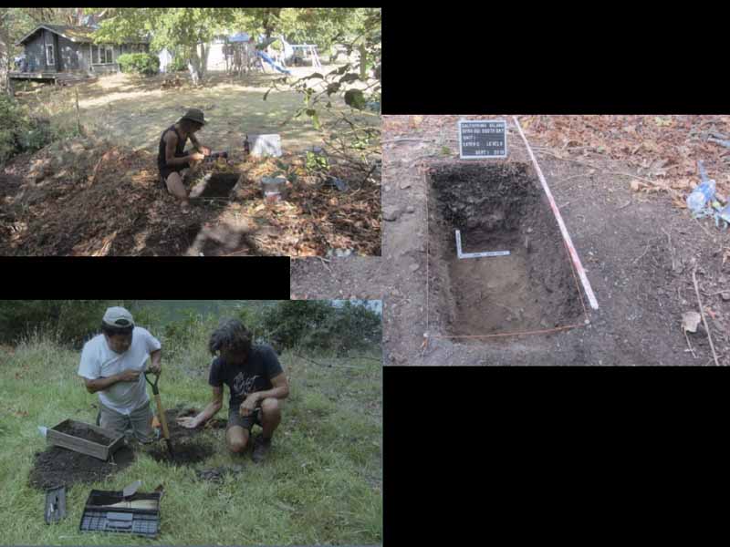
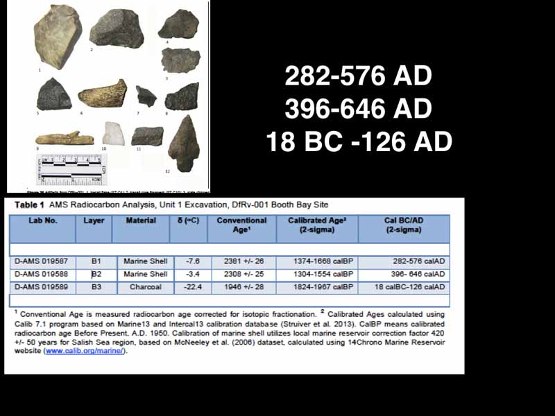
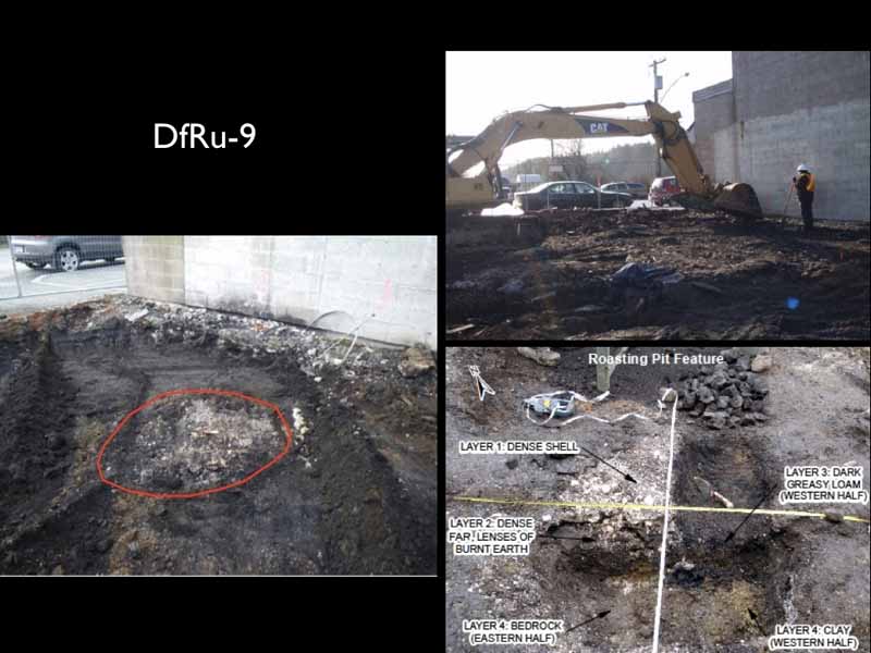
Still here, it's not here, I guess. Anyway. Yes, to do. So we're gonna start at the beginning of the canoe, Portage. And not Boothbay. This is what the early settlers called Boothbay oak Bay. Now, why would they call it that? Probably because there were tons of oak trees, you gotta remember all the land. And so those things changed so much in the last 150 years. And we were working on this property here doing some archaeological impact assessments and stuff. And this, I wish somebody was standing next to this tree because this is the largest Gary oak I've seen on Saltspring on this property, huge, and it's some, you know, the beach is down here. So I have a feeling this whole area was covered in OAKS, you know, in 1859. Anyway, and this is the, this is where that the property was we were working on this is the head of the canal. And this is Boothbay and this is the entrance here, and this is all a very large archeological site. This may be the site of a village quick site women, not sure. And we did some archaeological work. So I'm gonna talk about a bit of archaeological work that we did on this side of the canoe skid, and on the other side, just to give an idea of how long people may have been using this. So here we are working on this property and you know, archaeology in BC, you know, people want to build on known archaeological sites, they have to go through a process Thus, mitigating the impact on the sites. This is why we were hired to do this on this particular property. And you know, we everything was fine, but the property owner kindly allowed us to do extra work, because we're such Keeners. So we went and dug some of our own units just to take the opportunity to collect some scientific data. And so we did just one little unit in here, and found all kinds of interesting things, radiocarbon dates, here I am working with Irwin Knut, who's a hereditary Grave Digger, from Cowichan, all of the First Nations workers that we work with in archaeology are grave diggers, because makes sense because we're dealing with the dad. So they're the most appropriate people to help us out in our work. And so here, we're doing test pool holes, and just, you know, looking for stuff, this is more controlled excavation, very, you know, two centimeter level is very time consuming, and we're collecting all of the data that we uncovered, you know, it's just not, you know, it has to be done very systematically, because as you're removing the soil, you're destroying the site. So everything must be recorded meticulously like camera by recording, you know, basically making a three dimensional map of what's under the ground. And this is a very interesting site covered about an acre. So, and just under the surface is this huge layer of all this firecracker rock, it was extensive, just all over the whole site, we're still not sure what it was about, it had something to do with processing huge amounts of food, maybe Camus, we just don't know. Because, you know, archaeology is always a sampling issue. You see this tiny little hole in a two acre property, and you're just getting a little glimpse into what's there. But important glimpses. So what did we recover from that little unit? Well, here's some artifacts, we found scrapers, bone, harpoon fishing points. And a an intact projectile point, which is kind of rare to find, in archaeological context, people find them in the beaches they find on roads and things in the woods. But this one was found in archaeological context. And then we also got the owner to, to cough up for radiocarbon dates, which is super nice. And we got these dates from that little unit. So here we go. We got you know, 282 to 576, ad 396. So you know, over 2000 years ago, people were doing activities at the site. And this just shows you the, the the radiocarbon analysis, it's, it's expensive, these customer $300 A shot. So you better make sure you get a nice sample, uncontaminated. And then it goes through a whole process. So we got these dates for marine shell and charcoal, and then you have to calibrate them, because there's a radio active carbon that kind of contaminates the sample that's brought in through from what they call the marine reservoir effect ammonia and fit into all the details. So you have to cloud read all the dates, and eventually, you've come up with the actual dates. There we go 2000 years. And it's nice to correspond exactly with the typology of this type of arrowhead. We have a very good typology for all the arrowheads and projectile points that people find around here. So we know just by looking at it, I mean, this one is dates from the same time period as radiocarbon dates. So that was kind of cool. So let's see those dates just came out of this little unit right here just in there 2000 years. But they have all the dates. So this is part of the site says is it the old Atkinson Boothbay resort, there's the entrance to the canal. And here you can see where somebody put a road through these huge mitten deposits, house platforms, and look at these things. So huge. So these suggests to me that this is a village site, this could be the village of what's going on. And elders talked about a village being here. And so this is probably the village site, but it's never been explored really, just tangentially. So we're gonna start now we're gonna go along this canoe route. Just sort of traverse it and see what we I'll give you an idea of what it looks like. This is the beginning. There's the head of the canal. We were just at up here. Oak Bay Boothbay? It has a lot of other company names, but we got those. I liked that name, but cyclamen, this area is sort of the large canal those of you know this you know, it fills in with water it's really a beautiful spot that high tide, but they would, they would do these Portage this or or they would take canoes in here only when the tide is really high. So and they knew the tides and knew winch ahead and so they would go in when this inlet was filled with water to get the, you know, as far as they could. And so this is the first part of it and this is taken from about sharp road. I'm not sure it's a show God You need a clam garden? Not here. But Saltspring has six clam gardens. Different different parts of the island from the bridge. This is from the grid. Yeah. Okay. Good place for sign, right. So yeah, it's probably the other side of the bridge, because it's pretty mucky. And so this is where they would come in at high tide. This is not high tide, obviously, they would come in as far as they could, and then connect up with a Ocampo Creek, which is right here. And this is all you know, a lot of different property owners in here. So when we went into 2017, we got permission from all the owners and cooperation, it was great. To start, I've sneaking in here, another time period when I was less ethical. But um, but you can see how it's nice and level at the beginning because this canal or this creek is, you know, low level Creek. And so I went in here to see if I could find any sign of the canoe skids. But I didn't find any. So in 2017, about July 2017, a bunch of us from the stork society and local property owners walked the whole route. So it was kind of fun to see it's very dry, the creek is all dried up. And we're just going along looking for any evidence, you know, whatever artifacts, any kind of physical features that might suggest the the old route that we didn't really spot anything. But this is fun to traverse the original route. And this is on the hunt property. That last picture is taken over here somewhere down in here. And you can see how a lot of property owners have have changed the course of the creek and modified the land quite a bit by building ponds and things along the route. This is interesting here the hunts and they acquired a new single collection of artifacts found from this little flat here, which I couldn't find a pictures of but and I talked to Richard Mayer, Kenny, I mean, a lot of people who live on the street have found artifacts over the year, which is not surprising over the years, which is not surprising, because it was a well traveled route. So this is where those ponds are and so or that was that last pond so we're just going to continue along. And cool thing is this, this place really opens up in here like to get the best of you. And so I suggest you go up to the the cider place and have a drink and look down and you get a great sort of view overlooking this big, wide open valley that lies between birth canal and Ganges. And again, very level flak. You have no problem dragging a canoe along here, especially if you had these quick lemon poles. You know if it's got a little gnarly, you could drag it a little more. It's been heavily farmed, and ditched over the years but still retains some of its original look. It's probably much more heavily wooded. We're not sure. The ground here is very alkaline, hard packed. This is of course in July. It gets pretty mucky in the summer of Sir in the winter. And just some more pictures of going through the foxglove This is Christmas daughter forgot her name, we know.
Speaker 2 43:19
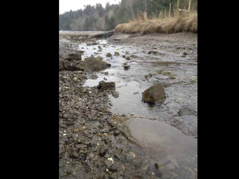
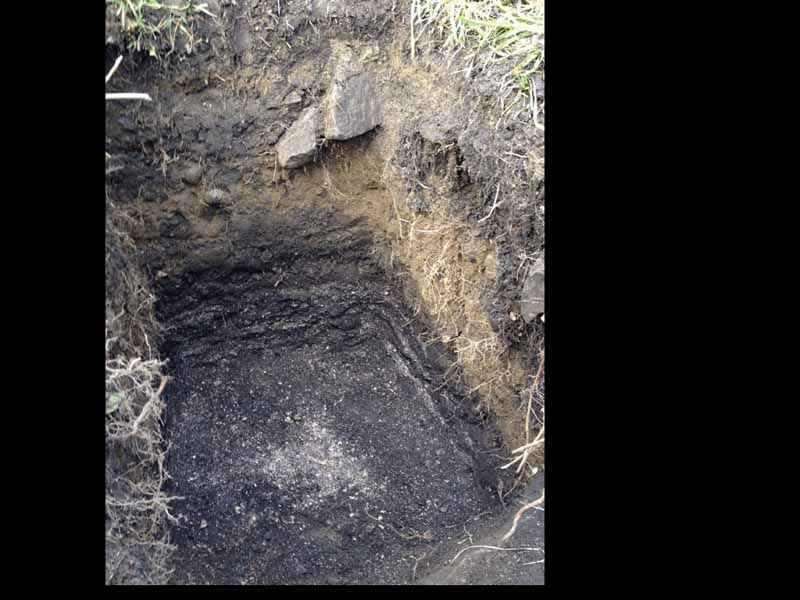
Anyway, she wondered what we were doing. And secondly, climbing fence. So we had a climbing stance pretty gnarly, go with barbed wire fences. She was really cool. And so told us a lot about the property. And so here we're nearing the sort of the height of land and going along just you know, examining rocks and any outcrops or any kind of features. And but it was all mostly level until you get up to about Atkins road. And that's where I figure they had the, you know, major bunch of these segments laid out to facilitate dragging the canoe over. And so yeah, so that was probably the hardest part up in here. And then once you go down here, it's pretty level pretty straightforward. It basically followed the route of Rainbow Road and then veers off down this way through. Well, it's sort of changed over the years there but probably down in front of artspring and then came out comes up here at Ganges harbor right by the what was Island escapades, which now has some a new business there and they got into a little trouble because they were mucking around and it's an archaeological site so they're doing everything properly. But here is the route that would as you know, just prior to entering the harbor and if you look on the beach here, lots of evidence of firecracker rock and stuff from the archaeological site. Shell Ganges harbor which is a large site on the HRF one I think it's called very large site all Ganges is built on top of this site. She helped. So there's kind of the route, we went zoomed in here. And then it kind of goes up in here and then down here and then probably went down this way. And then came out here and still see Kennedy's Creek. And this is the village of Scheldt. Here, and I'm going to look at some, some of the archaeologists shout, just to give you a bit of a sense of the depth of time here. This shows the extent of the archaeological deposits that she out, you can see it's all the entire village, there's great silence, which a lot, no doubt, at all. Gracepoint here also covered with deposits and things, you know, evidence anyway. There was just shocked. So there was an there was an interview, Reverend Wilson, who a lot of you know about, he's a chronicler of Salzburg in the late 20s, late 19th century, he interviewed an early settler, who I think was John Booth. Somebody has been here since the 1860s. And they had quite a long interview with this fellow and he quoted him at length in one of his in his writings. And he talked about how in June and July to be up to 500 Native people in Ganges harbor harvesting these butter clams to process them. And this is a drawing showing sort of how it's done. They would seem the clams, you know, have a big fire, get a big fire going. And with a lot of rocks in it, let the wood burn down, rocks that heat up, then you dump buckets of clams on top, and then cover them with mats and see we seen them open. And then you pull the clams out, and you stick them on the sticks. They sort of get cedar sticks and split them down the middle and fit these clams in. And then they put them around fires like this. And they would barbecue them for a few days, maybe until they're rock hard, then they squish all the juice out of them. And then they were threaded on these cedar roofs. And then they were wrapped into a sort of a ring. So you'd have these big rings. And so to gather these Ganges harbor, and they also gathered herring roe and all these food items, that they they didn't use them back in their own villages. They took these with them on their way to the Fraser River. Because this this the scene that the settler witness back in the 1870s, when he saw, you know, 500 people, these people were on their way to the Fraser fishery, but they stopped off in Ganges for a week or two, to harvest all of these foods that they use to trade with the interior Salish people. So we're talking into karma of Fraser Canyon living area, and so on, and they would trade it for Jade and soapstone. Mostly from that village of fluffiness, that sort of the base operations, they also harvested that herring row where they were for Cedar boughs in the water, when the herring responding around the same period are a little earlier actually. And they withdraw this and also use it as a trade item for the mainland people to trade for all kinds of other things. So how long has this been going on for? You know, we have this, there's some debate about this migration over to the mainland. Like I said, there's legal battles going on between the various Native groups. Some claim that the Cowichan only started going over there after the epidemics. But I think I don't think I don't believe that, because of the proxy evidence that we find in archaeology. And I'm just going to show you some examples. This was a so here's diligent, shelter Ganges. Now, and this is some work that was done a few years ago, when they tore down that beautiful block of buildings there and built the whatever it's called. Yeah, Mark's work wearhouse. So in the course of that, they uncovered a large burial site from the Marple period, 2000 year old burial site. And this is just show some of the graves here. And some of them are still there, on underneath the road, actually, between this place and the gas station. And, you know, they were they were supposed to put up a marker to commemorate that, and they never did. I think they should, that was part of the deal. Anyway. So these grades were excavated, and here's some of the evidence, you know, they had it. I don't agree with this type of archaeology, this is CRM kind of mitigating, you know, time is money. Let's do this really quick. Here. They're excavating with a an excavator scraping off that there's a sad archaeologist watching. And, you know, it's a very crude way to explain a cemetery. But anyway, this is the way it was done. And they did collect a lot of interesting data like this large, ceremonial hearth is a ceremonial fire because when they bury people, they often do a lot of burnings and things and what evidence of it but this is really mucky, messy work. But time is money. So everything sped up. I think they should have spent half a year doing this to do it properly. But anyway, that's, that's just me pitching anyway, in these graves relative grave items, including these marvelous things these are this is a jade Celt, this is nephrite, this material doesn't come from here, it's only found in the Linton and Lloyd area, which was and that was, you know, way up past the Fraser Canyon to British Columbia. And here's some arrowheads that were also found in the grays. But the this is what did he call it? They call it a CELT. But it's a I would call it an ads, because it's got a very sharp edge here. This is nephrite, which, on the Mohs Scale of Hardness is about eight or nine, which is almost stuck, you know, it's it can hold an edge like steel. This is how Native people built those giant houses that we showed earlier. This is how they made their beautiful carvings. Because they had a cutting material that was almost the hold an edge, like I said, as almost as fine as steel. And these are from here. This is the proxy evidence of the trade going back 2000 years, because this day, these graves will date from about 2000 years ago, same time period of those excavations that we're looking at earlier. And some more than I'm going to show proxy evidence for the wonderful smoke clams, and smoke carrying that may Ganges famous for centuries. And as a friend of mine, you collect stuff on the beach, here's some more these nephrite as these are all found on the beach, in Ganges harbor, and there's a stone hammer. But again, here proxy evidence of trade with interior Salish people. This is an excavation we did at the head of the harbor back a few years ago, just where that kiosk is, you can see our little unit here, that's silver and and helping out. And I'm working with Eric McClay, who some of you may know, and we just, again, this was a CRM project, we're trying to mitigate the impact of this walkway. But being you know, gung ho Keeners, we decided to excavate down and get a better window into this place. And it's interesting, because there was an archaeological outfit that worked here a few years ago. And you can see this overburden here from road construction stuff, they dug down a little bit, and they decided that the site that disappeared, little did they know they're standing on two meters of cultural deposits. Anyway, we dug down a little deeper because, you know, we're Keeners and we hit levels of house floors. And we know these are house floors, because I've excavated a lot of long houses, and you're digging in is this stuff. And it's like cement. And it's like cement, because it's so compact hid from people walking on the floors of their houses, their house, their house floors, were dirt with compact broken shell, but it's
Speaker 2 53:12
you know, it's hard materials are going down, and no artifacts, nothing because you know, they're tidy, people they cleaned up, they didn't leave stuff valuable Jade adds a line around. So but eventually, we got down to the base of this, look at this. So the next time you drive in there between movies, and upper Ganges road, you're driving over two meters, 2000 years of cultural deposits. And here are all the radiocarbon dates we got from this work from all these different levels. This is interesting here, here, the house floors, which started about after 1500 years ago, prior to that these deposits are really loose and indicate more kind of seasonal visits. Or maybe the houses weren't on this exact location. But after you know, the definitely by this time period 1486 dense houses here, you know, people living here 1859 sort of the cutoff point this is when the first settlers came here. But as we know from that account from John Booth, Anita people continue to come here for the next step well up until the feeding government prevented the the helping young people from from they're going across the street. And but yeah, this is quite a story here. I love these stratigraphy. It's a book really, of the past. And then of course 1859. Here's the canoe scared and preempted by two black American settlers. George Richardson and Walter Isaacson never hear about these guys, which surprised me, but they they were the first settlers in Ganges and there's the village of shout. Again, like I pointed out marked off separate wasn't part of the these. And these gentlemen, they got a lot of harassment if anybody's read left tenant Richard mains book for years in British Columbia, Vancouver Island, he came here in the Congo in 1862. To because there were complaints from these two guys, that the native peoples have been raiding their, their gardens and harassing them, let you know, they had their preemption right on a major travel corridor. So, surprise, surprise. But anyway, but of course, over time, this land was completely alienated. There was there was quite a period, you know, between 1859 and the mid 60s. There's a lot of tensions around here. A lot of harassment, you know, snipers and stuff like that. It was a not a safe period to be living in this part of the island. And one of the reasons is that none of these people, even the white guy here, Linacre, married native women, and this is very different than the north end of the island and the south end were the first settlers all married Indigenous women who owned the rights to the land, and so they occupied the land and live there unmolested and their families still live here today. I just dropped my car off at Irwin collision crew and the trigger when is still keeps in touch with Connecticut. He's he's been elegant. And Sampson family Penelope Hagerman family commitments and earn requirements and confinements so and they still maintain connections with their their relatives, which is really cool. But shelter is not a reserve and I'm researching this stuff and I'm gonna find out what exactly happened but involves getting into a lot of going to England actually but anyway, so that's an overview overland canoe route the show itself of between booth canal and Ganges but there's other ones that I've heard about and when you look at the the way the islands are laid out here you can see these long lists Mrs. Is my is Mrs. Is mine. Where you know there's an arrow little places where you can you know, instead of paddling all around here you can zip across, and I heard about one from I was at over and hooked me in a treaty group office and Scott showed me a map and, and he just he told me about one right here at Wilbury Bay at the ferry terminal. So here we are, there showed we're here in Ganges. And this is Sat stuck, which is the name of long harbor it means halibut and it refers both to a halibut fishery that used to be here in the distant past, or maybe not too distant, and to a geological formation of here that has the appearance of the halibut because I heard I learned this from an elder and he says a petroglyph was it rock art and said no no, it's a natural feature in the rock. So every time I take the ferry I'm looking looking looking and I haven't I mean I see some kind of look like one thing to do is to go along in a canoe and the thing to leap out at me but anyway, that's the name step but we're gonna look at the canoe Portage here is right at the ferry terminal. And it was right here. People well breathe bay or long harbor took the shortcut. Right here. This is a an archeological site. If you go there and you're waiting around for the ferry and 10 slip around here, you'll see traces of Shell mitten and down on the beach, but in the old days as a sub to the late Bob Garin muskogean, he told me this, and his family is originally from Connecticut. This was shell mitten, and they actually moved the shell the discarded shells to create sort of an area where they could skid canoes between mulberry Bay and and long harbor and back and forth. So that's it. I'd say cut Sam. little window into another little known until now. aspect of Saltspring island. So yeah, any questions?
Speaker 3 59:27
Left? Yeah. Spring I live on the canal. That was called original intention was to make a shortcut between the west side east side of any truth and then it was abandoned.
Speaker 2 59:48
Yeah, cuz, well, the settlers all knew about this. And so it's just something that was people always knew about and said, Well, why don't we do it? Nice Drummond Yeah, I'll do a rap ya know that that that idea comes from this era because we've got, you know, early missionaries talked about, you know, native people dropping them off at that in the bay, and then they would hike in. And then the natives would bring the canoes in later to wherever they were. So I gotta do more research. We don't even know where John, this original cabin was. You know, there's a lot lot of research we have to do. And so it would be a good key because a lot of these accounts refer to his cabin and going from booth canal to his cabin. I'm not sure where it was. It may have been on Ganges harbor somewhere. But yeah, that people you know, it's a natural idea when you look at the lay of the land to push it through. Yeah. The describe what the fire rock looks like. Charred Yes, but something else. Oh, yeah. It's question is just recap. What How convenient.
Speaker 1 1:01:10
That is, if it's just a sort of a localized area, or is it a group of
Speaker 2 1:01:19
cultural? Yeah, thanks for that. Yeah, hope to meet him is a Island version of welcome alien. And the word actually comes from an area of the Fraser delta, where the language is believed to have originated, in fact, they believe that the Delta area is is the origin of the of the Salish language group. It actually the earliest Yeah, that's where originated and then spread over a huge area, like up into the middle interior, you know, up to Williams Lake area, to Idaho, down to the Columbia is the language group that grew out of this area. And so that word helped come meet them is derived from ni command, which is a place name on the Fraser delta. And there's different versions, like how comedian is the language spoke, you know, it's a local version. I spoke on Vancouver Island. Then there's punk comedian, which is spoke by Musqueam. And so often, and then there's Hotham Elam, which is spoke from New Westminster up to hope. So it's this large sort of language of the coast of the Salish language family, that but also has all these variants. And like I said, at the beginning, that variant, variability went down to the village level, in the old days. Here's what the elders told me, they say, you could tell where somebody was from the way they talked, someone from humaneness Croc like this, somebody over there talks like this faster. So that sort of disappeared. Now, he's language is the one thing about how can they and how can they learn? There's a quite a few fluent speakers. So of all the languages around here, it's probably the one that has the most hope of surviving, because it's still kind of used in certain families. Not everybody, but there's a chance that it'll hang on there because of the number of fluent and partially fluent speakers. And then your other question is about firecrackers rock. If you go to any kind of beach around here, any Bay, especially where there's a mid and you'll see these reddish rock, sandstone, granite basalts that is broken up. And the sandstone of course, is all reddish or dark, usually reddish color. And yeah, you'll like we've all had fires, campfires. And if you look for that, and you know, you build them as rock hearts, and the rocks crack like breakaway through the rock. Yeah, they just break Although it's interesting you mentioned because there were actually good quality rocks that they used to use. And they even had a name for them escapes me the name but they were black rocks that never cracked. So if you were real serious, you know, fire makers something or you're roasting something or baking something using a pit oven, you would use these special rocks but often people just grabbed whatever rock they could and in this area is sandstone and sandstone you know I don't know if you guys would go fires without it explodes sometimes don't use it in a sweat house. Sand stones but yeah, if you go down the Ganges harbor there in front of that escapades. You'll see tons of it anywhere around here. Yeah.
Speaker 1 1:04:33
ductus canal like dependent one. We have four Island trustees.
Speaker 2 1:04:39
Maybe more interesting. In that canal. There's another overland canoe skid, the one in Pender Harbour. And that actually, it's interesting. You brought that up because that Pender that site is the oldest data site in the Gulf Islands states over 5000 years. Yes. A lot of use for skinning the canoes, or you said they charge them they burn. Yeah, just slightly. Is that to make them preserve longer? Or why do they burn? I imagined it was a preservation thing, because I would have thought you just peel the bark off and be nice slippery stuff. But yeah, I was just looking at it this morning, my handy Hoquiam dictionary. St. Lenin said, you know, yeah, they talked about these poles being stripped and then charged a bit. And my son's building a little house, actually, it was a cedar siding. And he's using this Japanese style to preserve the wood by charring the outside surface, and you get this really nice charred sort of charcoal look. And it's also preservative. So there could be a preservation thing to it. And the other question, yeah.
Speaker 1 1:05:53
Yeah, by getting through the evening with high tide, getting through there in two hours, is very impressive. Maybe, maybe some of the stories that are embellished by fishermen here.
Speaker 2 1:06:07
Today, the only way is to do some experimental archaeology. You know, we'll grab that new canoe and just call that thing. Yeah, but two hours. They Yeah, they claimed it. Yeah. Because you know, it's a well established route. And you do it at the right time with the tides and you know, strong people doing it for 2000 years. Yeah. You mentioned
Unknown Speaker 1:06:36
trust in the Delta.
Unknown Speaker 1:06:43
1858 59 and on the mind, this was coming by Victoria Cross.
Speaker 2 1:06:52
A wide range is was the interaction with the minus Oh, little bit, you know, the phrase a gold rush, so it was just sort of a one off thing happened very quick. You know, when 1858 30,000 Miners show up in Victoria, they all had up to the Fraser, by within a year most of them have gone. So they were pretty ephemeral. But actually the ones that stuck around settled on the San Juan Islands and stolen from us eliminated. Well, no actually hadn't even well. It depends what epidemic you're talking about. The one in 63 didn't really impact people here, because they're all already had an immune an immunity to it. The 1863 epidemic hit like the Haida, northern people terior Salish, because the Coast Salish, they had their first epidemics 1782. So way before that, but it did a number on the settlements here because obviously, you know, I showed you that early map with all the different village sites, you know, those were wiped out? Probably, and only one or two reoccupied, like one in Fulford, one in north end of the island, and then show
Speaker 1 1:08:12
video presentation about the silver van travel would be from that period of 17.
Speaker 2 1:08:21
Oh, wait before, I think they've been using this for 2000 years, at least. And, again, you know, they said on the proxy signatures of jade and soapstone that we find in all the archaeological sites here. That's the proxy evidence of trade. Clams, and herring row, which still preserved well, in the BC interior. Yeah. Earlier you had a map showing the couch. area. Yeah. Was the area just Sanish? Yeah, it's so yeah, it's kind of hard to divide these places up. You know, that's kind of a legacy of the Indian Act and the land claims stuff. You know, the government's forcing the natives to where's your territory? We don't know what we're dealing with, you know, how much is gonna cause these borders roll permeable in the past? So these sort of boundaries would refer to kind of concentrations of language or peak work where people would tend to speak a certain language, but you know, for example, in Fulford harbour, just as many whole community people live there is Saanich people just reading a neat things called the saltwater. Yeah. You're describing how a lot of American San Juan, orcas were part of the Spanish. Oh, definitely. Oh, yeah. San Juan Island was owned by songhees Victoria people Saanich connections with the Lummi we all know the Lummi and Bellingham. Their major village used to be in Sydney Harbour arena that mudflat the pass by the ferry terminal. They just moved over there 1830s And just got caught the other side of the border, they used to go back and forth. I used to know Earl Clarkson, senior, the late middle class and he would go over there in the 30s. And he remembers the first time or coastguard stopped them, they're going over in the dugout canoe that had an outboard on it pretty cool. And the boat just came up training machine gun on him and said, You're not coming over here again. But they never thought anything of it. It's like a lot of native people say me, we didn't cross the border, the border crossed us. But yeah, these just refer to general areas, unfortunately, now in the land of land claims, you know, they're getting a little more like us, you know, this is mine, kind of thing. In the old days, people move back and forth people from couch and married people in Saanich, and so on, oh, back and forth. And, and that was the major part of crusade was social organization was the practice of exogamy, which means you don't marry people in your village. Or in your households, you marry people outside of it. And that was done deliberately to span the network of, of kin and resources. Because the children so say you had a woman from Jimena severe demand from sadness, the children of that union would have access to the food gathering areas of both families. So it was a really cool way to distribute wealth throughout land, and maintain all these connections like the same one that people went back and forth. From vancouver island to the mainland, there was no animosity, because they've been doing it for a long, long time and has well established connections between all the different communities for one or two more questions. Or any kind of distinctive division. Cultures between
Unknown Speaker 1:11:53
both manual and the Senate.
Speaker 2 1:11:57
Not until the coming of the Europeans and the one place is down in Fulford Harbor, we bought the leaf off acre mean, used to tell me was a certain creek that went across the valley, and I know it by site by Jones road. And that was thought of as a boundary. But I think that boundaries established because of the the Douglass treaties and things these people are becoming aware that the fornito needed some kind of boundaries, so that we could, you know, protect our lands. So they began to kind of develop these, but they weren't hard fast in the old days. In fact, there was a rule. Well, actually was there was a really harsh rule of No Trespassing if you trespass on someone's land, it could kill you. But you know, it sounds pretty harsh, like oh my God, but that never happened. It never happened. The only people who can trespassing when Edom, and they began to get killed. And if you want to find out what happened, read my book, The terror the coast, I won't go into it. So let's see one more because you
Unknown Speaker 1:12:58
all have your explanations. Have you ever found any bits of cattle? No, because I understand that paddles preserve well, as well, even in the ground. And I wonder if
Speaker 2 1:13:15
they do turn up. And I can't I can't think offhand of any canoe, paddle or canoe. But I know wouldn't artifacts turn up? Now that I know of unsold spring, but it depends if it's a waterlogged deposit. Actually, the delta is an amazing place for stuff like that. They found basketry there. In fact, they found a basket that they dated to about 2000 years ago. And lo and behold, when somebody studied the the basket manufacturer, it was a Vancouver Island basket found over in the Delta. Don't tell him that's been that.
Speaker 1 1:13:50
Research people with canal was named by Japanese who used to have a fishing fleet that was often based in England. And they had an incentive to actually put a canal through constructed
Speaker 2 1:14:15
canal. Yeah, that's what this this lady was already saying. Yeah.
Speaker 2 1:14:27
Yeah, no, I just I mean, I've heard that story since I moved here. And I don't know where it's actually written down. Or maybe it's just something we've always heard history. Yeah, oral history that and it was an obvious thing because especially from people that live here in the 19th century, and they grew up here and lived into old age into the early 20th century. They were well aware. Can you skit like news to us because we've forgotten about it. I didn't know anything about this until I you know, I been living here for almost 12 years before I knew about this is the only because I interviewed too All those who had the information
Unknown Speaker 1:15:02
thanks a lot for this very informative very interesting
Unknown Speaker 1:15:13
October

