Salt Spring Island Archives

| a presentation to the Historical Society Central Hall |
|||
| Date | April 12, 2017 | ||
| Media | digital audio recording | mp3 √ • 57 minutes | |
| ID |
 sshsW.001.jpg
 sshsW.002.jpg
 sshsW.003.jpg
 sshsW.004.jpg
 sshsW.005.jpg
 sshsW.006.jpg
 sshsW.007.jpg
 sshsW.008.jpg
 sshsW.009.jpg
 sshsW.010.jpg
 sshsW.011.jpg
 sshsW.012.jpg
 sshsW.013.jpg
 sshsW.014.jpg
 sshsW.015.jpg
 sshsW.016.jpg
 sshsW.017.jpg
 sshsW.018.jpg
 sshsW.019.jpg
 sshsW.020.jpg
 sshsW.021.jpg
 sshsW.022.jpg
 sshsW.023.jpg
 sshsW.024.jpg
 sshsW.025.jpg
 sshsW.026.jpg
 sshsW.027.jpg
 sshsW.028.jpg
 sshsW.029.jpg
 sshsW.030.jpg
 sshsW.031.jpg
 sshsW.032.jpg
 sshsW.033.jpg
 sshsW.034.jpg
 sshsW.035.jpg
 sshsW.036.jpg
 sshsW.037.jpg
 sshsW.038.jpg
 sshsW.039.jpg
 sshsW.040.jpg
 sshsW.041.jpg
 sshsW.042.jpg
 sshsW.043.jpg
 sshsW.044.jpg
 sshsW.045.jpg
placenames.mp3
sembly.ai
12.01.2023
no
Speaker 0 00:00
Going to talk about a subject I've been interested in since I was a teenager. I grew up in Vancouver, beard inlet, 4th generation Vancouver, eight. Our family came there in 87. So I've always been interested in history. I was interested in the colonial history, history of my family in Vancouver. And wasn't until I was a teenager, I got a hold of a book called conversations with cost. Was done by a was put together in the 50 s by Vancouver city archivist major Matthews.
Speaker 0 00:26
And so I got to hold this book. And this book is like an, an amazing book. And it was based on conversations with native elders in the 30 s. But what really blew my mind about it was the place name. Because, you know, I grew up in this area of familiar all the history, you know, the nonnative history. And all of a sudden this book was filled with place names of Vancouver, like for for, you know, siwa, Rosa, kales, or for, you know, all the different names. And in these names is a whole hidden history that I hadn't been aware of until then.
Speaker 0 00:55
So it really taught me that, you know, language, place names is really a window into other cultures. And I'm also a historian, and I was excited to learn this material. And I began to study archaeology, because I don't think history ends or begins at any certain time, like a lot of people think history begins with the Europeans here, and nothing could be further from the truth. You know, the history here goes back thousands of years. And so a lot of my work involves, you know, joining that nonnative history with the, with the native earth, the the joining the native history with the nonnative history, because it's just a long continuum. So place names are part of that. So when I moved to a cold spring, you know, I got very interested in the history of this island.
Speaker 0 01:38
And so I'm going to talk about indigenous place names here, and how they give us this window into the past that we, you know, wouldn't otherwise have. So we're really lucky to have these names. So the title to talk, if they're the place, the people have a name for it, indigenous place in salt spring island. I didn't come up with this title as Roberta did, but she based it on a something I mentioned to her when I was working in the Stein valley in the 80 s. I was doing ethnographic work for the Li 1st nation. And one of my drives us to document place names in this valley. So I would interview elders about the areas in the valley where they used to go and and and gather things or with their stories.
Speaker 0 02:19
And one day I was, you know, asking an elder about place names. And he said, if there's a place, Indians got a name for it. So that really impressed me. But, yeah, you know, because people have been on the land for so long, for thousands of years, intergenerational knowledge, I mean, people were intimately familiar with the land, particularly when it's part of their, you know, economy. So moving around in the land was essential to their economic wellbeing. And so when I moved to salt spring island, I got really interested in this material here, because, you know, again, it gave me that insight into the past. It's kind of difficult to find otherwise, you know, place names have, have it all.
Speaker 0 02:59
So, you know, I began interviewing people. Before I get to that, though, I just want to and talk about the names. I mean, we're and the native people who live here are part of the Greek Salish nation, if you want to call it that. It's a, it's a huge area that goes from the East side of Vancouver island all the way to Idaho, up towards, you know, Lilly area, or even further up to, you know, dog Creek, and then down to the Columbia river. This is a huge area the Salish nation. And in in this area there's about 25 different languages. And even in this area here we can see, yeah, some of the different languages, the different dialects of hokum.
Speaker 0 03:43
And so here's filtering in the middle here, and you see these linguistic design advice go right through the island. So up here you have a hook can eat them. Language, which is a dialect of health related to all these other languages that go up the Fraser. And then right down here you can, you've got some shot them, which is also called the Straits language. And it's a very different language, a lot of common words, but there's different as French and German kind of thing. So, but lot of linguistic diversity in this small area. And this is reflected in the names too, somewhat.
Speaker 0 04:19
So most of the names I'm going to look at today are in the Hoka Eaton language, because that's the language I'm most familiar with. And I've worked with a lot of come and elders, but I've also worked with a lot of St Jocelyn speaking people too. So I have a good, I think, a balance of of information about these place names. But one thing about the place names on salt spring, whether it's Hoka itam or sinot, it's the same word. They just felt slightly differently pronounced, different. So, and, and of course, each tribe has its own writing system. That's the Joslin writing system.
Speaker 0 04:53
And that's the whole one a little more computer friendly. So you have to have a bit of command of this language to, you know, learn to play names. So, so I began this on my own when I moved to Saltzman. I've lived here almost 30 years. And then in 2003, we got a tiny little bit of money from the archives for traveling expenses. So bard linger and I decided that we would go out and interview various elders on Vancouver island and Penelope island who had connections to salt spring, old family connections. And like, for example, this gentleman, aar la.
Speaker 0 05:29
Some of you may have seen him, he's very active in the Grace islet saying. And Barb linger is a descendant of hominem woman couch, can speak from Clem Clement, who married, yeah, a settler, John Maxwell way back. And so we went around and interviewed these elders. And so a lot of the information I'm going to talk to you tonight was, has come from people like ar Charlie. I'd like to also acknowledge, acknowledge August Sylvester of Penelope island, Florence van Elliot island, the late Ray Sam, the late Dave Elliot, the senior of sandwich, and others who have been really sharing and and generous with their knowledge. And so in the course of this. We started collecting names.
Speaker 0 06:20
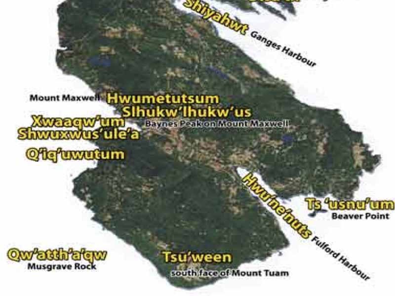
We started a map. So this, this is a map that you can see on the website. It's, it's a bit out of date, but we're going to update this. And so here you have maybe a dozen names. But we found in the course of our work and, and looking at the work of other scholars, we've got about 30 to 40 place names on from salt spring island. And these are just some of the more wellknown ones. And some, so I'm not going to talk about every name, because they'd be here for hours.
Speaker 0 06:45
And there's some names I can't scare yet, because they're still being kind of vetted through elders, like the people here involved in a treaty process. And so they're, they're really trying to get good, accurate information. And, and they, they vet all the names. Like they just don't say, Oh, that place is this name. You know, it has to be kind of go through the community and people react their brains. But we rate, you know, we're just, we're on the cusp of losing a lot of the knowledge. And even the people that have a lot of knowledge, there's so much that it, they're kind of overwhelmed by explaining it to us, for example, I went to interview one of these elders, Barb, and I went to interview an elder in Maat named but earned rice, very, very wellknown elder, very knowledgeable.
Speaker 0 07:25
And so I asked them, you know, you know, I want to learn about place names, place names on soul screens. Oh, no. And he's sitting there thinking, and then he starts to get into a very detailed story about going into Fulford Harbor. And there's a little rock in the water. Those of you who know Jackson rock off the Indian reserve there, there's, there's some rocks that are sort of submerged at high tide, and then when the tide falls, it's sort of just visible. And he was going into detail about that, and he says, that's papolo. Papolo, something on the water moving and stuff.
Speaker 0 07:53
And so and then he just stopped. And it was long. He spent about 20 Min telling me the story. And then what I realized, you know, he didn't have time to tell me every darn place name all over the island, but he was showing me this idea that, you know, there's a place, people have a name for it. And early settlers notice this too, like Captain Grant, who was one of the 1st settlers on Vancouver island. It wrote a very good description of Vancouver island. And he was, he was, he was amazed at the, the ability of, of people to name everything.
Speaker 0 08:22
So at every point, every rock, every, you know, weird tree had a name and a story associated with it. And he, you know, he said, these are places that the white men would just ignore. And, of course, they ignore it because they didn't know the history. But he compared it to, to another indigenous people, you're the Gaelic people. He saw the same practice in his homeland of Scotland, where these names reflected similar things about the landscape. They reflected, you know, the shape of the land, resources on the land and stories associated with the land. So he was struck by that similarities was kind of meat, which is the difference between indigenous people and, and, and colonists, because colonists don't have that history.
Speaker 0 08:58
Hence all the names on salt spring, like Fulford Harbor, Ganges Harbor, sub point. And these are all named after your Royal Navy officers. And as such, to denigrate those names, those are, you know, if, if there's a place, people have a name for it. And that's the name that were given to these places, you know, basically in a few short days, most of them are named by George Richard, Captain George Ritchie just sort of sailed by and name name, I just named everything. The salt spring was the biggest island was named Admiral island, every Admiral and so on. And all the ships, a lot of the names here, come from h and s Ganges, which was never here. H no.
Speaker 0 09:29
Managers wouldn't dare sail around these waters, or else we'd be exploring its wreck. So I'm going to go through a bunch of these, but starting with this interesting map. Some of you've probably seen this. This is the earliest reference to soul spring island that we have a historic record. And this was a map done by James Douglas in 1852. And so in 1852, they knew about this area. You see the map here is really detailed, and they're basing it actually, on early Admiralty math.
Speaker 0 10:01
Once you get up here, you notice it, like, what the heck's going on? You know, they had no clue. And so the reason this map was done because they found coal in an Ivo and so Douglas went to check it out. So he went on a canoe trip. You went around here, you know, this area that of year. And when you got around for a they noticed this huge, you know, island over there. And so, you know, he obviously, yeah, he had a guide with him.
Speaker 0 10:25
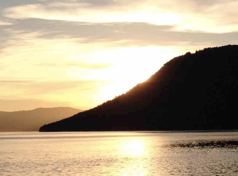
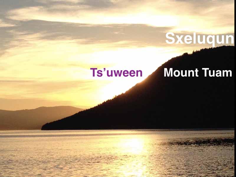
He asked the guy, you know, what's that place? He said, try on ton. And so Douglas assumed it was a name for the whole island. And so hence the name here, swan island. And of course, there's places on the island are named swan place and that, and, but that place name only referred to this land for him. So sway flame, which is a name for that portion of Salzburg island. And, and Twain just means coming straight down to the water.
Speaker 0 10:58
So if you're in Swartz bay, and you look over at salt spring, and you head and go towards salt spring, you know. And then when you get below the mountain, it just has this feeling shear, you know, coming down, shear from the top one for swaying. That's it. And of course, this name was later corrupted to hug form, is a derivation, you know, derivation of that indigenous names. So that's kind of interesting. And so, and you'll also find it's in the early colonial correspondence, they began referring to salt spring island Aswan island, swan or salt spring. And, and what you find is to go through the different communities and people, they named the island according to sort of their proximity to it.
Speaker 0 11:37
If you live sort of on this side, you know, in sandwich, or down in couch and, and you came over this part of the island, they used to call it, they, they would refer to it in general as to or flying, swaying, swaying. And if you went to the north side of the island, you'd refer to it as Poland, which is the salt spring. But we'll get to that in a bit. So second, so this is a very important place in, in the mythology of it. And if you go on the exchange of a little story there, I won't go into the whole story about this individual. Saha. That's a halo can with with an individual, but also a, it's also a place name on the top of Mount Tom somewhere.
Speaker 0 12:17
Now, Mount quam is a very sacred, important place. Like when you interview knowledgeable elders about the place, they won't talk about it. And so right away, if you aren't talking about it, you know that it's sacred and very important place. They're not going to start telling you all that, you know, the secrecy about it. But the story of the Hali and is basically a, the short vision, it means lightning eye, the lightning eyed. And he was an individual who went on and his vision quest and, and acquired, you know, incredible supernatural power. Is basically his power came from the Thunderbird trackless.
Speaker 0 12:48
And he had ability to just open his eyes and lightning was shoot out, and he was just burn anybody to a crisp who was in front of him. But so, so what happened, instead of using these powers that he had for, for good to help people, he began to become a sort of a despot. And he built a house up on the top of Mount quam, and began to enslave people and, and ordered them to send all their daughters and women up and send up food, you know, he was a total despot. So this is typical teaching in, in, in 1st nation stories, they're kind of negative teachings. There's stories about bad Behavior. And so when we started studying these stories, go, those natives are all crazy fighting and doing all this stuff, but really these stories are preserved to teach people how not to behave. So in this instance, he people begin to get set up with what he's doing, and they kill him.
Speaker 0 13:33
Eventually they bring up a big roasted seal, and they break it over his head and it covers them with all the fat, and then they the stab him to death. But he still believed to be up there. And it's interesting the, the area still has sort of a sacred quality about it. Because this Buddhist leader, rim posh, somebody, I'm sorry, I don't know his real name, selected the Buddhist monastery from the sky. They were, they were flying over salt street, you just pointed down. So that's where this monastery is going to be. How is?
Speaker 0 14:03
Hello? Yeah, yeah. He picked it from, yeah, from the sky. So it just shows this, these places have some sacredness that can transcend cultures anyway, but say, hey, look at yeah, very important place. So that's just the South end. Just to give you an idea about place names and some of the things associated with that, was just going to look up at the north end. Here's a detail from our map, and we'll look at, so that's, that's a name.
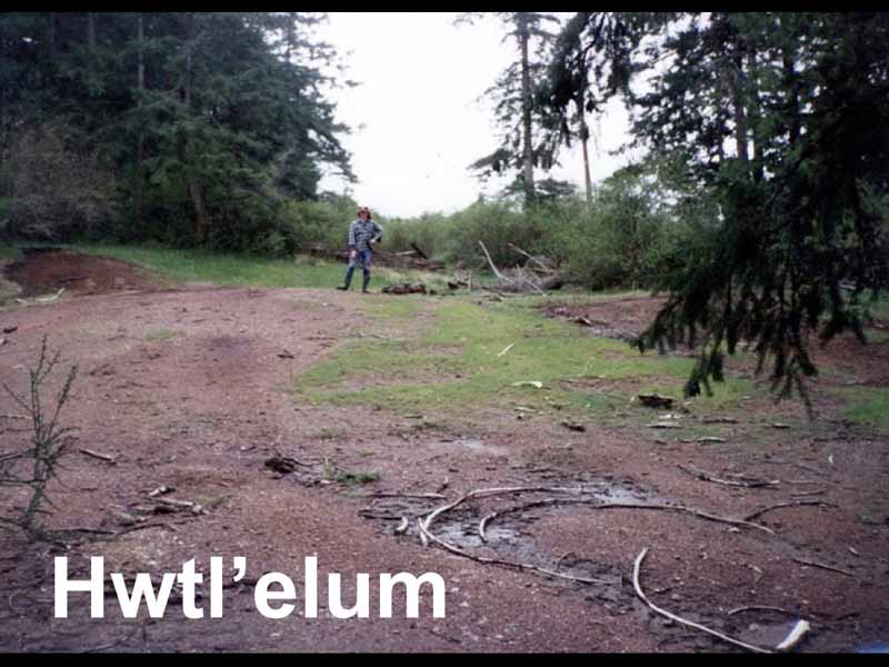
Speaker 0 14:34
So Swain has been preserved in Mount Ju and the only, the, the other native name on the island that's been preserved is a name for salt spring island. Salt spring, which is what, click one here. We've got on our map with Lakeland specifically referring to fern wood. But what Lakeland really refers to this whole area, including a same every late so it's basically the north end of the island. So if you're living on pen Connecticut island or over in Chima, they would think of salt spring as holu and, and, because that's but closest to their, their villages. And, and it's an area that had lots of resources. I mean, the lake is the largest in the Gulf islands, a very important place.
Speaker 0 15:14
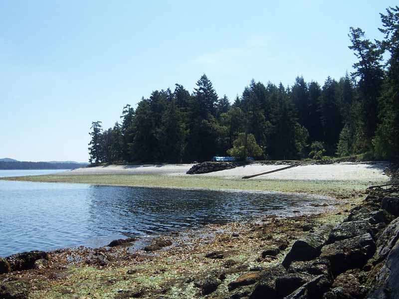
So quo place of salt, plate of salt, cut, place of salt. And it refers, of course, to all of these the natural salt springs. And here's one of them on one of the properties. They're, as you can see, spectacular and really exciting. Although you go here in the summer, and they're much different. Like they're basically low mounds, and the salt just piles, the water just perk out of the top and kills everything. Like hardly anything grows here.
Speaker 0 15:42
But in the summer it's all covered with white crystals. That's really quite beautiful. And I believe there's about 14 of these springs around. But, you know, these were noticed by the indigenous people, so hence the name. But of course, the most important place of quali is what hao, which is the same name for same areas, lake. And hatsa is, is a general name for lake, but it doesn't just mean lake. And when you know that, when you study the language, like ha prefix means something sacred, you know, spooky, unusual.
Speaker 0 16:13
And, and lakes were considered to have beings living in them. And, and we've, we've all heard about same areas lake, you know, people complain about its turbidity or phosphorus counts, and they blame septic fields and all this stuff. But really, this has been going on the lake forever. And was noticed by the native people way back. They would come to this lake and it be of some weird color. Well, that would indicate to them that it had some special properties. And this is another place that people never talk about.
Speaker 0 16:38
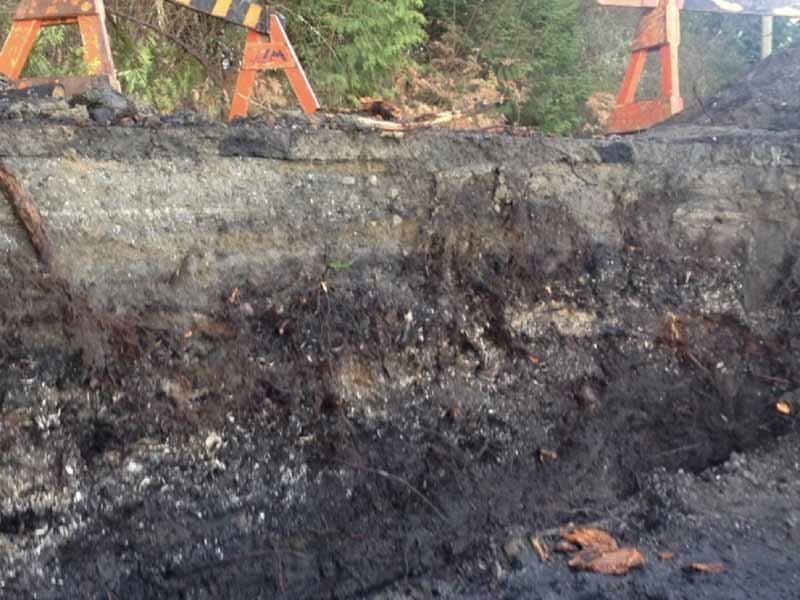
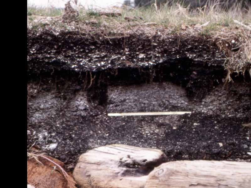
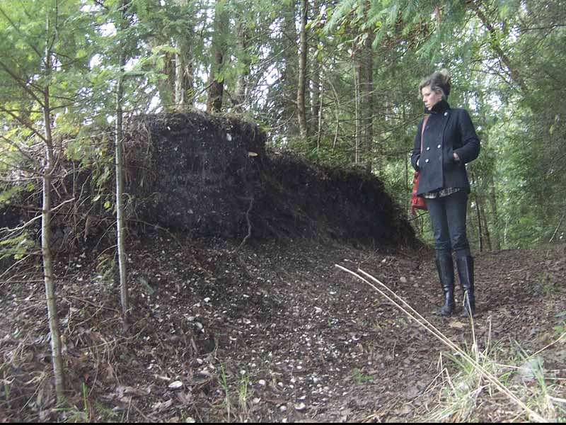
I'll just mention that, Oh, people went there to bathe. So if, you know, if you're forwarded by the culture, you know, okay, bathing, that's all spiritual training and stuff. And so, very importantly to people from all over. I mean, I've heard people in, you know, in the Victoria area, the song he's talking about this late. So it it had, you know, importance throughout the area. Was not a great slide, but people have been living in this area. You know, I'm an archaeologist, and, you know, a couple of years ago, the road fell away here, Adam, at Hudson point, and revealed this, you know, incredible stratigraphy of occupation here.
Speaker 0 17:14
And they've got some dates from here. It's about 2000, 2300 years old down here. And you see all this buildup over centuries and centuries, and then the modern buildup set the road. So up here goes, it starts with 1859 up to the the current occupation. But, you know, there's evidence, if you know where to look, of occupation in this island going way back. The oldest three department dates we have are about 4,000 years. But I'm sure people have been living on silence for upwards of 8,000 years.
Speaker 0 17:45
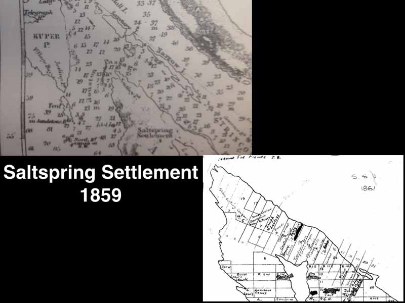
Another instance, well, salt spring. Another interesting thing is not great. Now we got to get a better now. George Richards map, and its 1st one, it shows the salt spring settlement up here. It's the only place name shown on Salzburg island. And course, it's a direct reference to Cole flu. Because when the settlers came here in 18, 59 and and preempted all these areas, and Walker took all the way up to a certain point, they ask, you know, the native people, what's the name is place?
Speaker 0 18:12
And they just what like, you know, what does that mean? Oh, salt spring. So they adopted the name. So it's the only go line when the retains, you know, one semblance of its indigenous, you know, connection and an indigenous place name. So, insulting cell 59, this is just a great map that somebody produced years ago in the archives, showing all the different preemption. And this was, they just didn't sort of occupy the land. Every one of these settlers married a native woman.
Speaker 0 18:41
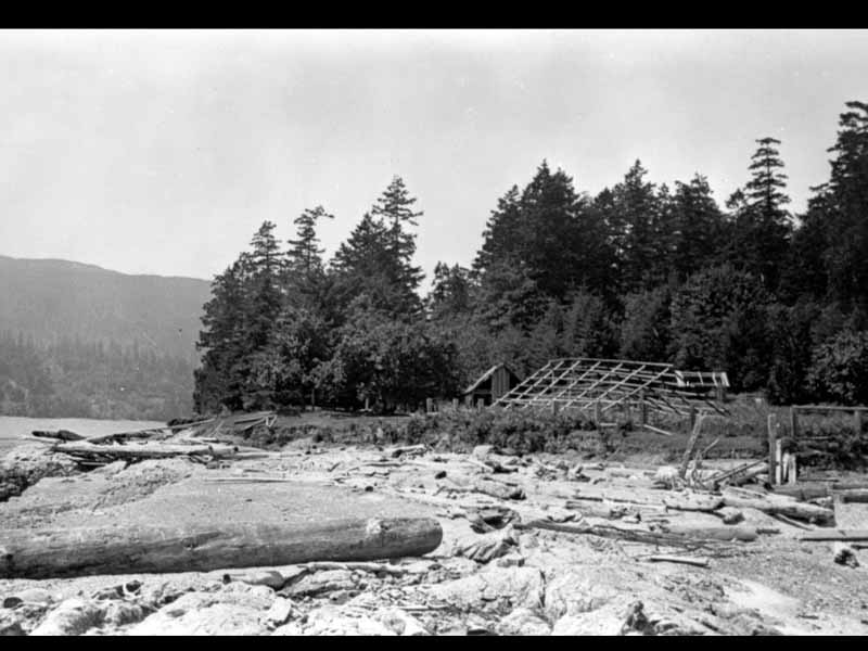
When the, when the Anglican Bishop visited here in one 60 and there were 16 men living here, all with native wives from surrounding areas, because that was the only way they were allowed to stay in the land, you know, because otherwise to be killed, you know, you they would not suffer trespasses. But if you married into the family, you know, part of problem. Who so another interesting place at the north end of, you know, puts down here and says, put on up. Lot of people remember this place. This is what it looked like back in the 60 s. This is from Marshall charts, you know, incredible aerial photography. And here you can see this old site, and there's an estuary here, and then a long, sort of burn of a shelved in, built here.
Speaker 0 19:26
And you see long houses up here. But that name put on up. Everybody remembers that name. And the name describes the this, you know, incredible feature. This the white shell beaches. Cook is white, un up his ground, white ground. And there you can see the the site's been a bit messed up by the the owner there, but they still deposits there.
Speaker 0 19:53
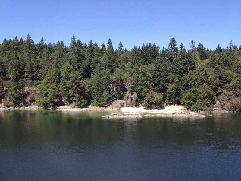
But let's put on up second, some white shell ground, just a descriptive term. And then there's this place, she Haman, which is Walker. So beach and Bavaria, interesting place. This is a large village site that's an anthropogenic spit. That spit wasn't made by nature. It was made by thousands of people living there on the land, building up the shell, midden and refuse over centuries, maybe a millennia. And it's an interesting name.
Speaker 0 20:27
This name, when I interviewed elders about it, and nobody could come up with a good translation for this name. It was like, Jackman, you know, the the guess, you know what it meant. And, but I live right here. This is just down below where I live, and it's a big bay here, and there's very interesting ausa qualities in this day. So one day I was out there, and I was out of my deck just listening and hear the waves crashing on the beach out there. I think that name comes from that. And that's not far fetched, because a lot of indigenous names, or what's the word, Omo, poetic pu hold them out of here.
Speaker 0 21:08
Thank you. You know. And this is very true of the of the Hulk eaten language, or any indigenous language around here, for example, you want to learn, start learning Hulk can eat them. You start imitating the birds, the red or seagull, those are all the sounds they make. And, and the same, a lot of place names come from the land. That's why it's an ancient language that literally has emerged out of the of the ground here. And, and the critters, the wind in the trees, has, has names that evoke those sounds, a statement.
Speaker 0 21:42
And there's just a, the beach is shape. And, and like I said, is shape line. This is all built up. And here's a photo I took years ago when there was some erosion, showing the remains of a side of a house. So you hear the floor the long house. And these are posts that stood along the house edge of the house holding the boards in place. This is a large long house.
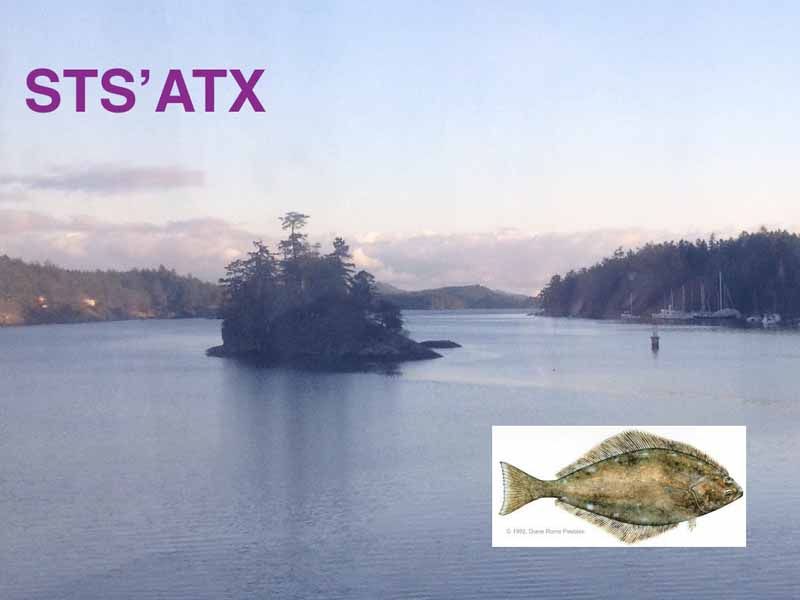
Speaker 0 22:03
The site's never really been explored, but it's a very rich archaeological site. Chapman, another great one, long Harbor, the hot commitment and the sun shot name all the names for in both languages. A stop. That's, that is this guy, halibut that apparently used to come in here, and they used to fish them here. And so that's one account I heard from an elder. And then I interviewed another elder, and he said, Oh, stop. There's a a rock formation on this inlet that he says, looks like a big halibut.
Speaker 0 22:39
So keep your eyes up when you're canoeing. And it's somewhere around the the entrance of long Harbor. But long Harbor courses lots of evidence of use. And I interviewed elders who used to come here in the 30 s and 40 s. And, you know, big clams collect herring, you know, they poult trees in the water, and the herring deposited road. That was a big, a big thing. And if you, if you, if you notice, as you're going along, you'll see little pockets, like there's a white shell areas.
Speaker 0 23:09
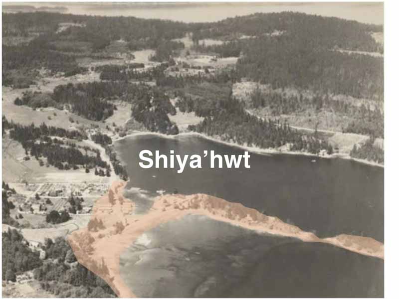
These are old camps sites. And some on long Harbor are very large. And there's actually burial mounds up in in the woods, in the back at certain places. So there's obviously a very large indigenous population. And SF, you did an archaeological dig here back in the 70 s, found the old estates on the island about 4,000 years old from a large site with about 40 burials in in an area less than a 3rd size of this room. So there's a lot of history buried there still, but very little has been studied. So now we're going to move to central island, or a central part of the island, and look at and here, this is my great postcard.
Speaker 0 23:48
When you go to moats, you know, you got to grab one of these. It's a, yeah, the good old days, actually. It is beautiful, but it gives you an idea of what Ganges looked like. Ganges area before the all the development. This is taken in the 30 s. So Ganges, his name, chili is the name for this area of Ganges Harbor. And and the original village site here, and split line is booth.
Speaker 0 24:11
They don't know what that word means. People don't know, a lot of these names have been kind of forgotten, because, like I said, there are these maybe Omni poetic names, or, or are so old, or are they, yeah, connections have been lost. And and strong is the name for booth canal and canoe skin. They used to go from a boot canal across overland, I think, kind of follows this creep in here, and then came out down here in front of the kayak plate. But this was a very well used a root that saved people. I've heard anything from some people said, you know, one to 2 h to get across here was dragging your canoe over Cory logs and things, as opposed to about 7 h of rowing. So lot of people accessed, this was a major kind of corridor from Chima couch and bay to Ganges Harbor.
Speaker 0 25:09
So I'm going to look at, here's just a showing you the the head of booth canal, where the beginning of this portage was started, you know, high tide, you bring your canoe in here, and then they go up a canoe Creek just a little bit inland here, and they would take it in quite a ways. And then when the ground got higher up, they would, yeah, there was a section of Cory logs. And I interviewed an elder on Penelope island, Henry Edwards, who told me he went here in the 30 s, and he could find traces of this old road still, but he left because he was afraid of the white people. So, but he went there to look for this old root that his elders had described to him. So why was this so important? Ganges? This is a map from 1955 from an anthropologist named Homer Barnett, who wrote one of the 1st sort of comprehensive studies of code Salish.
Speaker 0 26:01
And he was interested, you know, he heard a lot of stories about the people here doing this yearly migration to the lower mainland. And here you can see couch, and all these lines show like sand villages and the Nile people. They all converge on the Frazer river because of its incredible sock eye fishery. So people here were very much connected to this place called plot. And expl is up there. It's just past the George Massey bridge. This is a large couch and village.
Speaker 0 26:32
It was 2 mi long. A guy visited it in the 1820 s and counted a hundred and five houses and gave up. There's too many. So this is a huge honking village, and it was an amalgamated village of all the people from couch and SINA and Pinot island went there. Every summer. They would dismantle their houses here, take them over and rebuild them, and then do the stock ice fishery and involve and get involved in trade. The thing is, on the way over, they sought in Ganges Harvard to procure clams and herrings.
Speaker 0 27:07
This is all part of the, this, this annual migration. And we have a great account from John booth, an early settler, who describes Gandhi's Harbor teeming with Indians. He counted about 500. This is in 1870 s. And they were all just there. You know, 500 people came along that canoe route overland and began, then began harvesting clams and processing them. And what they did was they barbecued these clams and strung them on cedar wise, and then they took them over to the Fraser area and traded them with people in the interior.
Speaker 0 27:42
Not people down while muscly or squamish, but people way up around Lien area for Jade and soap stone. And so this is a major article of trade in Gandhi's Harbor. Was famous for its smoke clams and for smoked herring roe. And this is like a delicacy. It was traded all the way up the Fraser river into the BC. Interior. And I think this has been happening for, for, for centuries, thousands of years, because on the Gulf islands here, the archaeological sites, we find lots of Jade implements.
Speaker 0 28:11
We find soap stone. These are the proxy signatures of trade, this trade and seafood that went inland in exchange for items from the interior. And, and, you know, Ganges is a very important start along the way. And so how long have people been doing this? Eric macla and I did this excavation a couple of years ago at the Harvard house, still in the bank, by the kiosk, right under the kiosk. It's there today. And you can see this, this tells a story.
Speaker 0 28:42
And these are radio carbon dates that we got going back to those 2000 years ago, little over and so on, right up to 1859. And it was a very interesting when, you know, to read this photography, you can see different events. You can see where people are, are there, and the shell is all loose, you know, they're obviously processing clams and doing it maybe on route to the Fraser. And then when you hit up here around 14 hundred or so, after huge fire, the sometime fire event, then get these, yeah, layers that are habitation floors. So people are, are living there at Ganges full time. Like there's this myth on the island, you know, it's a pervasive myth, you know, the Indians never lived here, you know, the native people never lived on salt spring, you know, the archaeological evidence just flies, you know, face that it's just absolutely untrue. I mean, populations probably, you know, you know, to flourish over time, and, or different settlements would flourish, and then they disappear, you know, and then, you know, things would come and go.
Speaker 0 29:42
But overall, this is long sustainable use of resources for like, here's like 2000 year evidence of of sustainable, sustainable, intergenerational use of the land. There's no kind of disjuncts here. The people, you know, people who are down here, pet taji, are related to the, you know, the most to the Senate community today. So shell, and she wrote, was a large native village site. And this is a, somebody did this graphic showing the extent of the archaeological evidence, you know, all around here, you can expect to find Archelaus domains. There's Grace islet, of course, which is the burial islet of this village. You know, be islands are often associated close to the village, but off, you know, at one edge.
Speaker 0 30:27
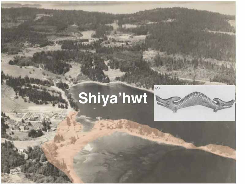
And the main village would have been here on that spit that's now Fulbright, Angie's road that runs across the market. But this name, shi ho, this is another one of these names that people weren't sure would have meant, let's see. Oh, and so I started to look at it literally and, and, and look at stories. And it means to be cautious of something there. Be cautious. And so what are they being cautious about? I, I surmise it's this thing back Gary, this is, yeah, this is, this is called a Sal key, which is a twoheaded snake.
Speaker 0 31:02
It's, you don't want to run, you don't want to run across when it eats, unless you feel you can, you know, Oh, outmaneuver it, out power, because it's, it's a deadly creature. And there was an account from an anthropologist named diamond Jeni interviewed an elder in the 30 s over in Duncan, and he talked about the sinal key lived in the head of Ganges Harbor. And those of you have been here long enough know that Ganges Harbor, the summer can get kind of, kind of, you know, kind of, you know, the water gets a little funny, and there were issues, you know, when they had the septic fields, but it's another condition where the, the water doesn't move around here. So it naturally gets kind of a, yeah, I can't even, I should learn the biological terms, but, you know, it just gets cloudy. And least attribute this to the sinal key. And this simple key, if, if you're walking on the beach, it would raise up its head and would squirt this kind of black goo at you and approach, and that it would either kill you, or if you were a powerful person, you would get power from it. So it's one of these ambiguous powers this is true of a lot of these indigenous mystical beings who live in the landscape.
Speaker 0 32:13
They, they, they can kill you, or they can help you. It all depends basically on your make makeup. So, and, and, but another thing he mentioned in this account was that he, he said that there was an early settler on gangs who his wife and his two kids were killed by the sinal key. So I'm going to see if there's an account. So it just shows you the danger of this being. But, you know, they associate this being, possibly with this change in the water, but it's just, you know, a supernatural being, she hopes. So be cautious of it.
Speaker 0 32:45
And here is a, a remarkable stone sculpture was found at Walter bay by a woman digging in her rose garden. It's about this big. It's a huge sandstone sculpture of possibly this being the cell key. The single key doesn't always have to have two heads. It's sort of a reptilian being. Can take many shapes, but who knows, with a spectacular pieces from soul spring island. So that's where we were yo stop.
Speaker 0 33:12
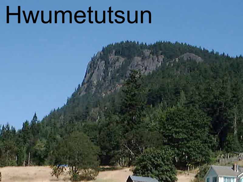
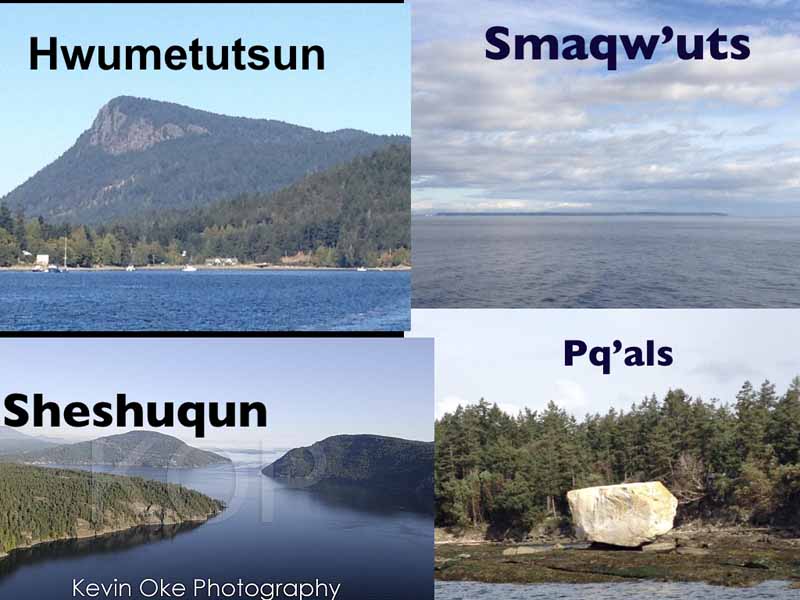
So now we're going to look at the center part of the island a few places. And, of course, mountain, actual, iconic symbol of the island. And it's the iconic symbol of, of of quite a story, too. And its name in the hook, and the name is K, which means it's a bent over place. Or, you know, Hutson refers to sort of a a shape bending over, and hot mas he is bending over. So why is this place bending over?
There's a so clear what now this shows another thing about these place names.
Speaker 0 33:47
They are connected to place names out so, off island. So the story, and there's an ancient story about this place, and all of these places, they're all part of the story. So these stories happen over a large area, and they're meant to connect these places together. So the story here, briefly, is there was a creature lived here, Jacobin rated octopus point. It was a giant head that was down at the the tide water. And and so when people went by, he would just open his mouth the water all come in in the canoes, he munch them up and meet him. And then people got a little wiser and went further out.
Speaker 0 34:22
But he had a long tongue, so he sent the tongue out, you know, you just said, one of these cannibal beings. He used to live here in ancient times, during the time at the schwa. And so they had a meeting up here at maple bay. You know, what are we gonna do about this creature? You know, disrupting our lives and all this. So there was one young man who decided, you knew a man lived over there, placed smos was his name. He lived over point Roberts.
Speaker 0 34:48
And so he said, I'll go to this man and see if he'll help us. So he did. He went this long journey over the mountain and pass, and he visited the SMU wiz. And the SMU was important. He was the 1st man in that area, but he also had, he was a giant and he was able to take huge stones and put them in his sling and throw them around at various, you know, whatever he wanted to to hit. And so, yeah, he told the young man, told him about this monster, and SMU would said, okay, I'll get rid of it for you. And he he put a giant stone in his flinging through it.
Speaker 0 35:22
And the 1st one just slammed a little short, landed up here. Play sold for calls. I'll see you picture in a bit. So there's a big white rock there. Then he threw another one and landed way over here. Lee said, bounced off Mount Max, will actually, so we get a little closer, land over there. So he fired a 3rd one.
Speaker 0 35:39
The 3rd rock landed down here is Patty milestone. Some of you probably know it. It's another big, glacial erratic sitting on the sandstone foresaw. Oh, yeah. So he said, three shots. So his 4th one, he says, okay, that mountain's in the way. I'm going to call on the mountain to bend over to give me a clear shot at this shape.
Speaker 0 35:57
And and so the mountain bends over, and he gets a nice shot, sails over and hits this creature in the face, knocks off his lower jaw. So he's never able to kind of open his mouth anymore, but he's still there. He just girl, and people still avoid the place. And if you look over there, you'll see the big rock with its jaw missing. So that's an interesting story. You know, these four place names, all in different places, all connected in this one story. It's what we have for.
Speaker 0 36:27
So my wife lives over there. And and Paco, next time you go draft and pass, have a look on your left when you're heading towards and have a look at your left to go island, you'll see this huge rock, giant glacial, a granite rock. That's a Picas. These Picas are everywhere. They're up at seashell. They're in Vancouver, you know, it's, it's a common story throughout the sailors area. And there's the octopus point, which shapes, then the wide open mouth.
Speaker 0 36:55
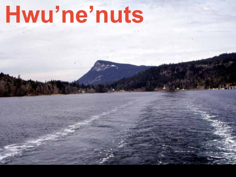
And and that story has a lot of teachings in it about, you know, perseverance, selfsacrifice. You know, all of these stories, you know, not just simple stories, they have a lot of cultural teachings embedded in them. I don't get into all of it. Want to talk about this place now, quite a there's Mount Maxwell up there. You can see that characteristic bent over shape is the name for ful fort Harbor. And there's some sort of, there's a bit of confusion about this name. If you, if you, if you change the N to an s, you get konets, is the name for sandwich peninsula.
Speaker 0 37:32
And that name for sentence means something about the the the rear end, nuts, you butt, or rear end of something. If you, if you look at sandwich from the ocean, you'll see the land are rising up, and then you see Mount Newton sticking way up. So that's his rear end. Thicken up a sentence, and it's describing the physical feature the land, this place for nets, the end means it's looking at something lower. So the translation, literal translation be like lowering rear end. And I've heard other, other translations, like a move your body over. And one guy even thought it related to a transformer story where transforming, supernatural beings were traveling through and they, they, they saw a deer, a man was trying to kill him, and it was a deer.
Speaker 0 38:20
And so they, they, they took the deers. The deer had two weapons he was sharpening. So the the transformer said, Oh, let me look at these weapons. We took him in his hand. The all these were pretty nice. And it stuck him on his head. And then got some arrows and stuck it up his but, and the deer went jumping off through the woods.
Speaker 0 38:35
And so there's not, there, there's some reference to that. A lot of people are embarrassed to talk about this, like there's something more to this story. They're not going to stare with me. Maybe something rude, I don't know. But this is probably the Monet place. This is, this was a quote. This is the village site, or one of the village sites.
Speaker 0 38:56
There's a few on this Harbor. And this is the end of Manh road. I'm sure a lot of you've been there. And if you went down there in 1920, what you see, you see a not much change. But over there is land all cleared in a giant long house. And that post belong to this couple, to Holton and his wife, a sia poet. Now to hello to Holton is also known as medicine man.
Speaker 0 39:25
Charlie. He was a Juana slam a shaman, and he was from Cain, and his wife was Maat San it. So she was part couch in part San. This place is now technically a sand reserve, but there are also college and interests in this property as well, because, you know, in the old days, everything was determined by your your family connections. So these people, they disappeared in the 20 s, around 21. I'm going to research it a little more. I've heard different accounts, you know, they were murdered and stuff, but the best account I heard from an informed elder, said that they died of they contracted measles on they way back from Yaki on they went off to die on their own somewhere, and just sort of disappeared so they wouldn't make anyone else contagious.
Speaker 0 40:11
So different stories. And after they disappeared, their house fell into ruin. You can see the long hats here, and then the chiefs house where they left behind, and it's all falling down now and and into the 20 s, you know, after, after the native people disappeared, this was a very popular terrorist attraction. You see these rocks off of them and off of the reserve there, these are burial islands. And this one used to be called skull island, and it was literally covered with human remains. And I talked to a 90 year old who grew up at who was born at Isabella point, he said people would regularly go over there to look at the the remains on the island, until one day they were removed by people from San and like everywhere on the island, there's lots of evidence of a previous culture, of a previous occupation. This is a huge, deep mound and in in Fulford Harbor.
Speaker 0 41:10
And sometime in the past, a logging access road went through here. A lot of people don't realize there's sites in these places. And so a chunk of this was destroyed, but there's still a lot of it preserved. But it's, it's, it's a very old, massive state. This stuff like this on Fulford Harbor, clam garden. This is at the entrance there in Isabella point. Parks Canada has been working on this.
Speaker 0 41:31
They like to describe this as an ancient plan. Go it's ancient. And they, they have been used for a long time. But I interviewed a guy born at Isabel point who worked on this clan between 1920, 1940. He went down there and described the whole process. The kids would usually move the rocks and the adults would do the digging, but the kids were the ones moving the rocks down the end of the beach, sort of their job. So, yeah, so there's next.
Speaker 0 41:57
Now we'll look at a few. Just a couple more. You know, I could go on and on, but see if there's questions. This one. Hock, a lot of you have been hearing about Hola lately, and that's the the hook and Eaton and St. Chocolate and chocolate name for burgoon bay. And it's named after female Megan, or duck, which is up there on the right.
Speaker 0 42:17
And almost every time I go down there, I see some, but I'm sure in ancient, or, you know, precontact times, there were, you know, thousands of I remember growing up in house sound, where there were, you know, thousands of ducks out in the ocean, and not anymore. And here you can see there, you see a cabin here. It's been torn down. You can see the evidence of a occupation. And of course, the Ackerman family is well known. They have wellknown connections to this place, because the Ackerman, the the the couch inside the Ekman family comes from club pus. This is one of their traditional areas where they gather food and other things resources.
Speaker 0 42:53
This is a great one that I love to talk, you know, talk about in schools, Cora, and that's Musgrave rock, but it means sort of an excrement on your head, the polite name. And there's one who was on poetic words like, I mean, you can guess you can imagine what that's like. Rip refers to. And the quo is on the head. So in previous times, there were more birds that was like covered with white, you know, guano and so, you know, expl head rock, something Islam. This is beaver point, and that's me. And you can see the, the midden down here.
Speaker 0 43:34
This is an a picnic area. And, yeah, a lot of evidence of use. And this is a very important site for sandwich and help people, you know, because there's fresh water here. It's a good camping ground. And it's sort of on the way between bank of R and the Fraser, because these people weren't stuck here. They were going back and forth to the mainland for, for, for generations, until the Canadian government soft it now. So it's not an interesting word, because that means it refers to tides hitting the point.
Speaker 0 44:05
So it's just sort of a physical description of, you know, this point of land sticking out there in the tides hitting it. But what's interesting, you find the same name in Vancouver. I don't know if anybody's heard of this Suan city before the city, this is referring to the, the old village village of musk, which stood at the foot of Grande street bridge. And it's, it's sort of called the marble site, an archaeology marble. This is where they defined a very early 2000 year old culture called marpol. And this is like the tight site. So it's a huge site and then buried, and eventually got buried into the Fraser on hotel and industrial stuff.
Speaker 0 44:40
But recently, must came, after a lot of effort, we're able to acquire part of it. And a couple, I think it was last year, they had a triple exhibit in Vancouver called susna, because that's the name. This is air spelling, but Susa is the name of that old village. And now that village is quite a bit inland, you know, the Delta's bit built up. But back with Suan was happening like 2000 years ago, the tides hit that, that place. So that place name, you know, refers to a place being hit by the ties, but exactly the same name that we have on salt spring island. So that's just a few, please name.
Speaker 0 45:18
This is a map that Frank will not put on the website, because I'll get trouble showing all the archaeological sites. I mean, as if you're going to find it without one, is they? And, but they refer not just to sites, but to isolated artifacts and stuff. But what I did here is a project and, and I found that there were a correspondence between the known place name, plot one Kuan, and village sites, which are clearly village sites, you know, big, deep mids with long, you know, occupations, evidence of house floors and stuff like that. And so we have some of the names, you know, walk on top will have me talk about these. But you can see all these circles up here where we don't have name. We don't have a name for beds beach.
Speaker 0 45:58
I mean, that is beat, you know, anyone who goes down is a whole large archaeological site. There's a lot of stories from the Betas family about native people visiting there, but we don't have the place name, and we don't have to place any resident point, very wellknown area where people lived at for a long time. We don't have that name. So there's still a ways to go, but there is a correspondence. So between the names that we do know today and the the the archeology of the island here, I think, one, two, three, four, five, six, seven, eight, nine, ten, eleven, twelve, three, four and 56, 17 villages were on this island. So you can think of like 17 little falters all around. That gives you an idea of the precontact population, the pre plague population, because most of these people perish around 17, 82, with a big epidemic that, within a short period of time, killed 90 % of the people.
Speaker 0 46:49
And so the lack of knowledge of place names is a direct reflection of that, that huge epidemic that, you know, destroyed so much, you know, so much life and so much history and knowledge. But thankfully, you know, some of these elders have retained memory of these places. And you know it, I don't know how much more we're ever going to find, because when I was interviewing elders, many of whom are dead, like back in the 90 s, and they were, they were like, close their eyes or try to visualize, you know, like canoeing, I'd say, well, tell me about the north end of salting, you know, the place names. And they close their eyes and just try to imagine going on there. And they go, I can't remember the name. Because, yep, the way these names were preserved by being on the land, all the all the teachings were there, went by Mount Maxwell, your grandfather would point out to it, tell you the story of the place, and the same of all the other place names. So there's great body of knowledge was preserved in the landscape with the place names and the physical forms of landscape.
Speaker 0 47:45
And everybody knew the history, everybody knew all these stories. It wasn't all secret knowledge or anything. Didn't matter you're from sandwich, palatin, Fraser river. Everybody knew the histories here. And that's all been lost, except for these few fragments. So that's my talk. A little, just a little taste.
Speaker 0 48:06
Frank and I are going to be working on a very Snook of map that's going to incorporate a lot of these names onto the island. And, yeah, thanks. Sector has been so I can take a few questions if anybody has. Yeah, back the nuclear island. Where, where did I find out more? Let's talk. Thank you very much.
Speaker 0 48:40
Where can I find out more about this? In the name? You start with the website. We have a bit of information on there. The 1st station section, or I remember it's anything is available to Oh, yeah, yeah, I'm, I'm a author of a book called terror the coast, land alienation and colonial war on Vancouver island in the Gulf islands. And another one called two houses half buried in sand, both available waterfront gallery, you know, and your better bookstores are but 9,000 years, it's the beginning of the okay, that is based on one unusual bypas that was found up at Channel ridge. So big leafshaped point.
Speaker 0 49:27
And but it wasn't found in in original context, but the typology suggests it could be 8,000 years old. And the earliest sites in this area, 6,000, on pander island. But, you know, and with the island, they found Pleistocene materials. They found a bi and kill site on Whitby or no, sorry, orcas island. So, which is data to about 12500. And I was recently at a conference in Vancouver society of American archaeologists, and there there was a lot of, you know, presentations on these earlier landscapes. And so I wouldn't be surprised if we'll find early stuff here.
Speaker 0 50:05
If, if we do find it's going to be up mounter skin, up on Mount Bruce. In fact, people are now working on Quadra island, relocating old sea levels and finding, you know, evidence way up like 80 M and up. So that's where the older sites are going to be. So we're still learning. Yeah, fine.
Speaker 1 50:24
Of I would really like to have a lot of these names returned to the 1st people's names. And I'm wondering, you know, of actions that are happening about this between archaeologists, 1st nations and other people of interest. I mean, welcome should obviously be that restored that name. And when I saw the long house magnetic area, people like, we should know that story. If we go to that site, we should know.
Speaker 0 51:02 Sure, for sure.
Speaker 1 51:03
You know, so how do we get things like that done?
Speaker 0 51:07
Well, let's say how do you like, when you talk about sharing with the 1st nation? You don't have to share, they know all this stuff. They know these names. We're the ones that have to get up to speed. And how you do that. I mean, there's books out there. School District 64 has saltwater people.
Speaker 0 51:21
There's a good book by Dave Elliot senior. He was the one that developed the Sans writing system that's down there on the bottom the
couch.
Speaker 1 51:30
And tribes has a dictionary book that's got all the play same in it, but you actually as long and up dog, Harvard, Harvard house. I mean,
you've, you've got some archaeological Oh, yeah. There, that's telling us, you know. Oh, yeah, we can do that other places.
Speaker 0 51:50
Oh, yeah, we're doing it. I mean, I've been working with Eric macla, and we've been at, we've actually gave a five different sites on the island now collecting rate of carbon days, but we're, we're still analyzing and putting it together, but it's all being shared of 1st nations, because that's standard archaeology.
Speaker 1 52:04
All the on the site that go there. And, Oh, your, your intelligences stories of it.
Speaker 0 52:13
Yeah, they'd be good to do. But there's issues, you know, the, the archeology branch is really, is, is against sharing this knowledge with the public. And which I disagree with. I think that everybody should know where these sites are and begin taking responsibility for them. Because they don't know about it. People were just going to go in as plays. They won't even know.
Speaker 0 52:31
But if you're a neighbor and you know, there's a big site down there, you know, you'll, you know, call them out. So it's sort of a, it should be something more open. Yeah, you find artifact, obviously, you do. Wherever you think, which museum do we go? Where can we go and look? Well, all the stuff that we find goes to the Royal BC museum in majority. Yeah.
Speaker 0 52:54
But it won't be on display. But you can go in there and make an appointment with a curator and they will show you like basically the stuff any archaeologist working today, like all the sites are numbered. And it's quite a rigorous system of permits and, you know, study. It's, it's, yeah, it's pretty rigorous because they're almost like legal documents. So well, they are legal documents. But you could go in there make an appointment, say, I want to see the stuff from Ganges Harbor. And they'll pull out a big drawer.
Speaker 0 53:19
It'll have everything that's been collected over the years by archaeologists, collectors. Yeah, pressure. But ideally, one day we'd have a
hero on the island. I mean, I would super we're, we're not there yet. Yeah, that so, yeah, is that that? Yeah. And that's under the site.
Speaker 0 53:41
That's end of the Walter bay site. And it's this big, huge I mean, it's an amazing thing.
Speaker 1 53:48
Really force the population on so island before the Atlantic.
Speaker 0 53:54
Wow. Well, so 17 villages there, if they're all occupied contemporaneously, a minimum of hundred to 200 people in each village, maybe 300 to be several thousands, I would say maybe even as high populations today, like we're still trying to figure this out. I've heard some estimates of the precontact population of British Columbia being 1,000,000. And do a whole that's, you know, crazy. But in the work I've been doing, I mean, I've been up in Douglas Channel and huge Channel here, the street community's there now, Hartley bay kit at one other one. And when you look out in the land, there's like 20, 30 former village sites. So this is all the way up down the coast.
Speaker 0 54:34
It's in the Gulf islands, everywhere. And these are the proc, this is what happened with demographic collapse. These people had all these sustainable, wellmanaged communities sustainable for thousands of years, they were doing it all right. And then when the plagues came, the whole system just collapsed. And now they're just trying to get back in it, you know, kind of hard because, you know, the resources have been trashed in the last hundred, 50 years, not even last hundred years. So it's a challenge. Yeah.
Speaker 1 55:02
And one of the 1st slides you showed the picture of two language groups on the island, yeah. Simultaneously using calendar, where
the they're different words.
Speaker 0 55:13
And, well, it's mostly just the proximity, mostly. I mean, actually, when you went back to these times, people spoke both languages. Like people heard of Snook. Anybody heard a snuff language? They always, Oh, they use this jargon because, you know, they couldn't understand each other. That's all. B s, because the white people invented that language, because they couldn't understand the native languages.
Speaker 0 55:35
And that language, Chinook, is, there's only 500 words. It's not a language these people all knew. I mean, you know, you live in here, it's like Europe. You go to Europe, and people, you know, I'm always humbled by, you know, the languages these people, I speak five languages, six. Same with these people here. Someone learning, somebody who spoke, can eat them. Could speak test in shortly easily.
Speaker 0 55:55
Today, not so much. They all notice the difference today. And there's so few speakers is like probably only five fluent speakers have said Scotland. I don't maybe not even that, maybe a hundred poca eat them fluent people. But so you have divide here at sea. This is, I mean, I don't know what to make of this divide. There's a bit of history in there, like 40, like things changed over time.
Speaker 0 56:18
Like, for example, in the 1840 s, there's probably more sandwich people living here, then hook come in people. But there were, there were events happening. There was a lot of warfare. There were natives coming down from the north to trade at fort Victoria, and they would raise the people on the way. And sort of a leader named lash is actually avid Charlie carries his name la. 1840 gathered people from gazi, main island and from pander and they'll relocate it down here to so it and follow it. That name means a fortified place.
Speaker 0 56:51
So what you happen, there are a lot of amalgamations happening is people, you know, gather together for and for, for better safety and in in greater numbers in fortified areas. But of course, they were down here. 1840, within 20 years, places overrun by nonnatives. And they never got back to the original places. But the saddest people here have quite a connection to gaes. I mean, they can't really articulate, but they just know it. Like I've talked to the most knowledgeable elders there.
Speaker 0 57:17
They can't tell you any story about gangs. They just know it's a very important place to our people. They just heard that. But because they haven't, people haven't been out on the land, they haven't got it. Because when you're up in the land every year, you'd hear the stories over and over and over again. You'd, you know, sick of looking all these rocks and stuff, but you would know all those stories. And now that a lot of that stuff's gone, so we're dealing with just fragments of it.
Speaker 0 57:43
But yeah, language is.
300_Arnett_The-People-Have-a-Name-For-It
otter.ai
24.04.2023
no
Speaker 1 0:00
going to talk about a subject I've been interested in since I was a teenager. I grew up in Vancouver, Berardi inlet, fourth generation Vancouver, eight, our family came there in 1887. So I've always been interested in history, I was interested in the colonial history history of my family in Vancouver. And wasn't till I was a teenager, I got a hold of a book called Conversations with customer Leina was done by was put together in the 50s by Vancouver city archivist major Matthews. And so I got to hold this book. And this book is like an amazing book. And it was based on conversations with native elders in the 30s. But what really blew my mind about it was the place names. Because you know, I grew up in this area familiar all the history into the non native history. And all of a sudden, this book was filled with place names of Vancouver, like for stat for Silas Ross, for chaos, or for, you know, all the different names. And in these names, there's a whole hidden history that I hadn't been aware of until then. So it really taught me that, you know, language, place names is really a window into other cultures. And I'm also a historian, and I was excited to learn this material. And I began to study archaeology, because I don't think history ends or begins at any certain time, like a lot of people think history begins with the Europeans here. And nothing could be further from the truth, you know, the history here goes back 1000s of years. And so a lot of my work involves, you know, joining that non native history with the with the native history, earth, that joining the native history with the non native history, because it's just a long continuum. So place names are part of that. So when I moved to Salt Spring, you know, I got very interested in the history of this island, and claim to talk about indigenous place names here, and how they give us this window into the past that we wouldn't otherwise have. So we're really lucky to have these names. So the title of the talk, if there's a place that people have a name for it, indigenous place names Saltspring island I didn't come up with this title is Roberta did, but she based it on a something I mentioned to her when I was working in the Sinai valley in the 80s. I was doing ethnographic work for the first nation. And one of my jobs was to document place names in this valley. So I would interview elders about the areas in the valley, where they used to go and gather things or weather stories. And one day, I was, you know, asking an elder about place names. And he said, if there's a place, Indians got a name for it. So that really impressed me thought Yeah, you know, because people have been on the land for so long for 1000s of years. Intergenerational knowledge. I mean, people were intimately familiar with the land, particularly when it's part of their, you know, economy. So moving around in the land was essential to their economic well being. And so when I moved to Salt Spring Island, I got really interested in this material here, because, you know, again, it gave me that insight into the past, that it's kind of difficult to find otherwise, you know, place names have it all. So, you know, I began interviewing people. Before it gets to that, though, I just want to talk about the names. I mean, we're, the native people lived here, part of the great Salish nation, if you want to call it that it's a it's a huge area that goes from the east side of Vancouver Island, all the way to Idaho, up towards, you know, Lloyd area or even further up to, you know, dark Creek and then down to the Columbia River. This is a huge area, the Salish nation, and in this area is about 25 different languages. And even in this area here, we can see some of the different languages or different dialects of Holcomb, aylen. And so here's something in the middle here, and you see these linguistic design advice go right through the island. So up here you have a hook can eat them. Language, which is a dialect of help from anyone related to all these other languages have got the Fraser and then right down here, you've got st Jonathan, which is also called the straits language. And it's a very different language, there's a lot of common words, but there's different as a French and German kind of thing. So a lot of linguistic diversity in the small area. And this is reflected in the names to somewhat. So most of the names I'm gonna look at today are in a hot commitment language, because language I'm most familiar with. And I've worked with a lot of help Canadian elders, but I've also worked with a lot of the Sawsan speaking people too. So I have a good, I think a balanced information about these place names. But one thing about the place names on Saltspring, whether it's in Hopkinton or St. Shortland. It's the same word you just spelled slightly differently, pronounced different so and of course each tribe has its own rating system. That's the rating system and that's the whole kimete And one of the more computer friendly so you have to have a bit To command of this language to, you know, learn how to place names. So um, so I began this on my own when I moved to Salt. I had lived here almost 30 years. And then in 2000, or three, we got a tiny little bit of money from the archives for traveling expenses. So Bard Lingard and I decided that we would go and interview various elders on Vancouver Island and Connecticut Island, who had connections to Saltspring old family connections. And like, for example, this gentleman Arbic Charlie was team. Some of you may have seen him, he was very active in the grace eyelet, saying, and Barb linkerd is a descendant of a calcaneum, a woman couch and speak from Clem plantlets, who married a settler, John Maxwell way back. And so we went around and interviewed these elders. And so a lot of the information I'm going to talk to you tonight has come from me like arbitrarily, I'd like to also acknowledge, acknowledge that August, Sylvester if inelegant Island, Florida seen inelegant Island, the late race, Sam, late Dave Elliott, senior of Saanich, and others who have been really sharing and generous with their knowledge. And so in the course of this, we started collecting names, we started a map. So this is a map that you can see on the website, it's a bit out of date, but we're gonna update this. And so here you have maybe a dozen names. But we found in the course of our work and looking to work with other scholars, we've got about 30 to 40, place names on from Saltspring Island. And these are just some of the more well known ones. And some, so I'm not gonna talk about every name, because it'll be here for hours. And there's some names I can't share yet, because they're still being kind of vetted through elders, like the people here involved in a treaty process. And so that they're really trying to get good accurate information and, and they they vet all the names, like they just don't say, oh, that places this name, you know, it has to be kind of goes through the community, and people wrack their brains. But we're, you know, we're just, we're on the cusp of losing a lot of knowledge. And even the people that have a lot of knowledge, there's so much it, they're kind of overwhelmed by explaining it to us. For example, I went to interview one of these elders at Bard and I went to interview an elder in Malahat named Ernie rice very, very well known elder, very knowledgeable. And so I asked him, you know, you know, I want to learn about placing play scenes unsold screens, Oh, no. And he's sitting there thinking, and then he starts to get into a very detailed story about going into Fulford harbour, and there's a little rock in the water. Those of you who know Jackson rock, like the Indian reserve there, there's some rocks that are sort of submerge that high tide and then on top falls, it's sort of just visible. And he was going into detail about that. He says that pop Wallach Pollock, there's something on the water moving and stuff. And so, and then he just stopped, there was a long, he spent about 20 minutes telling me the story. And then what I realized, you know, he didn't have time to tell him every darn placing all over these islands. But he was showing me this idea that you know, there's a place people have a name for it. And early settlers notices to like Captain Grant, who was one of the first settlers on Vancouver Island, who wrote a very good description of Vancouver Island. And he was he was amazed at the ability of people to name everything. So at every point, every rock, every weird tree, had a name, and a story associated with it. And he, you know, he said, these are places the white man would just ignore and of course, they didn't know it because they didn't know the history, but he compared it to to another indigenous people here at the Gaelic people. He saw the same practice in his homeland of Scotland, where these names reflected similar things about the landscape that reflected you know, the shape of the land, the resources on the land, and stories associated with the land. So he was struck by that similarities was kind of neat, which is the difference between indigenous people and colonists because colonists don't have that history. Hence all the names of Saltspring like Fulford harbour, Ganges harbor Sunday point, these are all named after Royal Navy officers. And it's not to denigrate those names. Those are, you know, there's a place people have a name for it. And that's the name that were given to these places, you know, basically a few short days, most of them are named by George Richard, Captain George Ritchie just sort of sales guy and painting meaning it's named everything Saltspring was the biggest island was named Admiral island after the admiral. And so on all the ships, a lot of the names here come from HMS Ganges, which was never here. HMS Ganges wouldn't dare sail around these waters, or else we'd be exploring its wreck. So I'm gonna go through a bunch of these. But starting with this interesting map, some of you probably seen this.
Speaker 1 9:45
This is the earliest reference to Saltspring Island. We have an historic record. And this was a map done by James Douglas in 1852. And so in 1852, they knew about this area and see the map here is really detailed, and they're basing it excellent early. Admiralty master once you get up here, you know, this is like what the heck's going on? They had no clue. And so the reason this map was done because they found coal and an IMO, and so Douglas went to check it out. So he went on a canoe trip anywhere around here the oldest area that he and when he got around fort de he noticed this huge you know, island over there. And so now he obviously he had a guide with him he is a guide, you know, what's that place? He said, Tron Tron. And so that was the scene of it was a name for the whole island. And so hence the name here Tron Island. Of course, these places on the island are named Swan place and that and but that place name, only referred to this land for him swim lane lane, which is the name for that portion of Saltspring Island. And swaying just means coming straight down to the water. So if you're in store today, and you look over at Saltspring, you're heading towards Salzman, you know, and then when you get below the mountain, it just has this feeling of sheer know coming down here from the top, flat, swaying, that's it. And, of course, this name, layer corrupted to trois Thomas derivated derivation of that indigenous name. So that's kind of interesting. And so and you'll also find this nearly colonial correspondence that again, referring to Saltspring Island as Toine, Island, Toine, or Saltspring. And that and what you find, as you go through the different communities and people, they named the island according to sort of their proximity to it, if you live sort of on this side, you know, in Saanich, or down in Cowichan. And you came over this part of the island, they used to call it they refer to, in general as Toine. Or sloth slang, slang. And if you went to the north side of the island, you'd refer to it as Lakeland, which is the Saltspring. But we'll get to that in a bit. So so this is a very important place in in the mythology of it. And those if you go on the exchange, a little story there, I won't go into the whole story about this individual. That's a hurricane with an individual but also a, it's also a place name on the top of Mount Juan, somewhere on Mount Farms, a very sacred important place, like when you interview knowledgeable elders about the place, they won't talk about it. And so right away, if you weren't talking about it, you know that it's sacred and very important place, they're not going to start telling you all secrecies about it. But the story is that hey, look, and it's basically the short version is the lightning is the lightning AI. And he was an individual who went on and his vision quest and acquire incredible supernatural power is basically his power came from the Thunderbird checklist. And he had ability just opened his eyes and lightning was chewed out and you just burn anybody to a Chris, who was in front of them. But so so what happened instead of using these powers that he had for good to help people, he began to become a sort of a desperate, and he built a house up on the top of Mount swamp, and began to enslave people and, and ordered them to send all their daughters and women up and send up food. You know, he was a total desperate. So this is typical teaching in, in First Nations stories, that kind of negative teachings that there's stories about bad behavior. And so when we started studying these stories ago, those natives are all crazy fighting and doing all this stuff. But really, the stories are preserved to teach people how not to behave. So in this instance, he, people begin to get set up with what he's doing, and they kill him. Eventually, they bring up the big roasted seal, and they break it over his head, and that covers them with all the fat, and then they stab him to death. But he's still believed to be up there. And it's interesting, the area is still has sort of a sacred quality about it. Because this Buddhist leader Rinpoche, somebody said sorry, I don't know his real name, selected the Buddhist monastery from the sky. They're safe. They're flying over salts for you just pointed down. So that's where the smartest series is gonna be. Yeah, yeah, he picks a trip Yeah, from the sky. So it just shows this. These places have some sacredness that can transcend cultures anyway. Let's say hey, look at Yeah, very important place. So that's just the south and just to give you an idea about place names and some of the things associated with that we're just going to look up at the north end here's a detail from our map and look at so that's the name slain has been preserved in Melbourne and the only the the other native name on the island it's been preserved is a name for Saltspring Island Salt Spring, which is what flexflow Now here we are met with Cleveland, specifically referring to fairway, but what lake when really refers to this whole area, including St. Mary's lake, so it's basically the north end of the island. So if you're living on Connecticut Island or over into Maine This, they would think of such thing as select one. And because that's what's closest to their villages, and it's an area that had lots of resources, I mean, the lake is largest in the Gulf Islands, a very important place. So click Lake limb, place of Salt Lake was soft place with salt. And upper refers, of course, to all these unnatural Salt Springs. And here's one of them on one of the properties there, as you can see spectacular and exciting, although you go here in the summer, and they're much different, like the basically the low mountains, and the salt is pickled water just out of the top and kills everything like are they anything grows here. But in the summer, it's all covered with white crystals. It's really quite beautiful. And I believe there's about 14 of these springs around. But you know, these are noticed by the indigenous people, so hence the name. But of course, the most important place of quick Lakeland is with Lake Hazza, which is the same name for St. Mary's lake. And Hazza is a general name for lake but it doesn't just mean Lake and when you know that when you study Lanza hop prefix means something sacred, you know, spooky, unusual. And lakes were considered to have beings living in them. And we've all heard about St. Mary's Lake, you know, people complain about its turbidity, or phosphorus counts, and they blame septic fields and all the stuff that really this has been going on this lake forever. And was noticed by the native people way back, they would come to this lake and build some weird color. Well, that would indicate to them that it had some special properties. And this is another place that people never talk about. They'll just mention that oh, people went there to be. So if you know if you're informed about the culture, okay, bathing, so spiritual training and stuff. And so, very importantly, to people from all over. I mean, I've heard people on the Victoria area and songhees talking about this late. So it had, you know, importance throughout the area. Now, it's not a great slide. But people have been living in this area, you know, I'm an archaeologist. And you know, a couple of years ago, the road fell away here at Hudson point, and revealed this, you know, incredible stratigraphy of occupation here. And I got some dates from here. So the 2000 2300 years old, down here, and you see all this build up over centuries and centuries, and then the modern build up, separate roads. Up to the current occupation. But you know, there's evidence if you know where to look of occupation on this island, going way back the oldest three department dates we have about 4000 years. But I'm sure people have been living in silence for upwards of 8000 years. Well, Saltspring another interesting thing is not great. Now we got to get a better map. George Richards map in spurts when it shows the Saltspring settlement up here, it's the only place name shown and Saltspring Island. And of course, it's a direct reference to what Lakeland because when the settlers came here in 1859, and preempted all these areas from Walker's took all the way up to the point. They asked, you know, the native people, what's the name of this place? What like, what does that mean? No. Saltspring so they adopted the name, so it's the only goclimb and the routines, you know, what a semblance of its indigenous connection and an indigenous placing a great map that somebody produced years ago, it's in the archives showing all the different reactions. And this was they just didn't sort of occupy the land. Every one of these settlers married the native woman there a bit when the when the Anglican bishop visited here in 1860. There were 16 men living here, all with native wives from surrounding areas, because that was the only way they were allowed to stay in the land. You know, because otherwise they'd be killed. They would not stop your trespassers, but if you married into the family Potter program. So another interesting place that the north end of quitclaim comes down here, just put on a lot of people remember this place, this is what it looked like back in the 60s. It's from martial arts, you know, incredible aerial photography. And here you can see this old site and as an estuary here, and then along sort of burn of a shell been built here and used to be long houses up here, but that name put on it. Everybody remembers that name. And the name describes the
Speaker 1 19:37
credible feature this the white shell beaches hook is white and up is ground white ground. And there you can see the site's been a bit messed up by the owner there but there's still deposits there, but that's white shell Brown, descriptive term. And then there's this place, show Heitmann, which is Walker sick. And very interesting places the large village site that's an anthropogenic spirit, that spirit wasn't made by nature was made by 1000s of people living there on the land, building up the cell mitten and refuse over centuries, maybe millennia. And it's an interesting name, this name when I interviewed elders about it, and nobody could come up with a good translation for this name. It was like, yes, my guests, you know what it meant, and, but I live right here is just down below where I live. And it's a big day here. And there's very interesting acoustic qualities in his day. So one day I was out there, it was out of my deck, just listen and hear the waves crashing on the beach up there. And it goes. I think that name comes from that. And that's not far fetched, because a lot of indigenous names are, what's the word on the McCoy yedek Poletik. Thank you, you know, and this is very true of the of the hook any language or any indigenous language around here, for example, you want to learn start learning how can eat them, you start imitating the birds, the red. What do you see though, those are all the sounds they make. And the same, a lot of place names come from the land is white. It's an ancient language that literally has emerged out of the ground here. And the critters, the wind in the trees has has names that evoke those sounds a stickman. And there's just a visa statement. And like I said, chitlin, this is all built up. And here's a photo I took years ago when there was some erosion showing the means as a side of the house. So here's the floor longhouse. And these are posts that stood along the edge of the house holding the boards in place. This is a large, long house. The site's never really been explored. But it's a very rich archaeological site. Titman another great one, long Harbor, the hook can eat them and some chocolate name, all the names are in both languages. Stop. So that is this guy, halibut that apparently used to come in here. And they used to fish them here. And so that's one account. I hear from an elder and then I interviewed another elder, and he said, Oh, stop. There's a rock formation on this inlet. And he says, looks like a big halibut. So keep your eyes up when you're canoeing. And it's somewhere around the the entrance of long harbor. But long harbor courts is lots of evidence of use and I interviewed elders who used to come here in the 30s and 40s. And dig clams. Collect herring, you know, they fall trees in the water and the herring deposit row. That was a big, big thing. And if you if you notice, as you're going along, you'll see little pockets like white shell areas, either on old campsites and someone long hug or very large. And there's actually burial mounds up in the woods in the back of certain places. So there's obviously a very large indigenous population. And this if you did an archeological dig here, back in the 70s, found the oldest states on the island of 4000 years old from a large site with about 40 burials in an area less than a third the size of this room. So there's a lot of history of bury there still that very little has been studied. So now we're gonna move to the central island or central part of the island. And look at here this is my great postcard. When you go to mow it's you know, you gotta grab one of these. It's the good old days it's just beautiful but it gives you an idea of what Ganges looks like Ganges they're ready for the all the developments. This is taken in the 30s so Ganges is named she holiday is the name for this area. Again, Barbara and the original village site here. And slug line is Boothbay don't know what that word means. People don't know. A lot of these names have been kind of forgotten because like I said, they're these maybe on the plate names or or are so old, are they Yeah, connections with a lot. And shyness is the name for booth canal. And for a canoe skid that used to go from birth canal across overland and kind of follow this creek bed here and then came out down here in front of the kayak place. But this was a very well used route that save people I've heard anything from some people said, yeah, one to two hours to get across here. It was dragging your canoe over corduroy logs and things as opposed to that seven hours of rowing. A lot of people accessed. This is a major kind of corridor from chumminess couch and Bay to Ganges Harbour. So look at, here's just showing you the head of this canal, where the beginning of this Portage was started, you know, high tide, you bring your canoe in here, and then it go up a canto Creek, just a little bit inland here, and they've taken it quite a ways. And then when the ground got higher up, they would, there was a section of corduroy logs, and I interviewed an elder on that Connecticut Island. Henry Edwards, who told me he went here in the 30s. And he could find traces of this old road still, but he left because he was afraid of the white people. That he went there to look for this old route that his elders had described him. So why was this so important Ganges. This is a map from 1955. And anthropologist named Homer Barnett, who wrote one of the first sort of comprehensive studies of Coast Salish. And he was interested, you know, you heard a lot of stories of people here, doing this yearly migration to the Lower Mainland. And here you can couch and all these lines. So like Saanich villages and Nanaimo people, they all converge on the Fraser River because of its incredible Sockeye fishery. So people here were very much connected to this place called sluttiness. And focus is up there. It's just past the George Massey bridge. This is a large couch a village. It was two miles long. A guy had visited it in the 1820s and counted 105 houses and gave off to many. This is a huge pocket village. And it was an amalgamated village of all the people from calyx and semanas and Pelican Island, who went there. Every summer. They would dismantle their houses here, take them over and rebuild them and then do the sockeye fishery and involved and get involved in trade. So the thing is on the way over the sauce in ganseys Harbor, to procure clams and herring so this is all part of the this this annual migration and we have a great account from John Booth early settler who describes Ganges harbor teeming with Indians in a kind of a 500 This is an 1870s and they are all just there, you know, 500 people came along that canoe route overland and began then began harvesting clams and processing them and what they did was the barbecue these clams and strung them on Cedar wise, and then they took them over to the Fraser area and traded them with people in the interior, not people down by Musqueam Squamish but people way up around Litton area for Jade and soapstone. So this is a major article of trade and Ganges Harbour was famous for smoke clams. And for smoked herring row. This is like a delicacy that was traded all the way up the Fraser River into the BC interior. And I think this has been happening for for for centuries, 1000s years, because on the Gulf Islands here, in archaeological sites, we find lots of jade implements, we find soapstone, these are the proxy, signatures of trade, the sub trade and seafood that went inland in exchange for items from the interior. And again, this is a very important stop along the way. And so how long have people been doing this? Eric McClay, and I did this excavation a couple of years ago at the hardware house, just in the bank, by the kiosk right into the kiosk, the CEO today. And you can see this, this tells a story. And these are radiocarbon dates. So we got going back to those 2000 years ago, little over, and so on, right up 1859. And it was very interesting. You know, to read this particular you can see different events, you can see where people are, are there, and the shell is all loose, you know, they're obviously processing plants and doing an ad on route to the freezer. And then when you get up here, around 1400 or so after huge fire, sometimes fire that then get these pack layers that are habitation floors, so people are living there, again, just full time. Like this is myth on the island. You know, it's a pervasive myth, you know, the Indians ever lived here, you know, the native people never lived on Saltspring. You know, the archaeological evidence just flies in the face. It's just absolutely untrue. I mean, populations probably
Speaker 1 29:35
flourish over time and are different settlements have flourished and then they disappear, you know, and then, you know, things have come and go, but overall, this is long, sustainable use of resources for like 2000 year, evidence of state sustainable intergenerational use of the land. There's no kind of distance here. The people you know, people who were down here at Ganges are related to the you know, the most To the same community today. So it's yellow. And she was a large Native village site. And this is, somebody did this graphic showing the extents of the archaeological evidence, you know, all around here, you can expect to find archaeological remains, there's pretty solid, of course, which is the burial island of this village, you know, burial islands are often associated close to the village, but off, you know, at one edge, and the main village would have been here on that spit. It's now over Ganges road that runs across the market. But this needs to hold this is another one is names that people weren't sure what it meant. Let's see. Oh. And so I started to look at it literally and look at stories. And it means to be cautious of something there because it's, it's what are they being cautious about? I surmise, this thing. This is yeah, this is this is called a silky, which is a two headed snake, it's you don't want to run, you don't want to run across one of these. Unless you feel you can, you know, outmaneuver it of power, because it's a deadly creature. And there was an account from an anthropologist named Dima Janus interviewed an elder in the 30s over in Duncan and he talked about the centipede that lives in the head of Ganges Harbour. And we, those of you who have been here long enough, no, the Ganges harbour, dishonor can get kind of spent, you know, kind of, you know, the water gets a little funny. And there were issues, you know, when they had the septic fields, but it's another condition where the, the water doesn't move around here. So it naturally gets kind of can't even learn the biological terms. But you know, it just gets cloudy. And they used to attribute this to the silky and the silky, if you're walking on the beach, it would raise up its head and was squirt this kind of black goo at you and your face, and that it would either kill you, or if you were a powerful person, you'd get power from it. So it's one of these ambiguous powers. This is true of a lot of these indigenous mythical beings who live in the landscape, they, they can kill you, or they can help you It all depends basically, on your makeup. So and but another thing he mentioned in this account was, he said that there was an early settler on Ganges who his wife and his two kids are killed by the single case. So I'm gonna see if there's an account, so just shows you the danger of this being. But you know, they associate this being possibly with this change in the water, but it's just, you know, a supernatural being, she ought to be cautious of it. And here's a remarkable stone sculpture was found at Walter bay by a woman digging in her rose garden, it's about this big. It's a huge sandstone sculpture, possibly this being the selkie the silky doesn't always have to have two heads, it's sort of a reptilian being can take many shapes. But who knows, with the spectacular pieces from Saltspring island. So that's where we were repsonse yachts so now we're gonna look at the center part of the island a few places. And of course mountain actual iconic symbol of the island. And see iconic symbol of a quite a story too. And its name in the name is climate, which means it's a bent over place, or ottesen refers to that sort of a shape bending over and Hawkman it's he is bending over the why this place bending over. There is a so there's Now this shows another thing about these places, they are connected to place names outside off island. So the story, and it's an ancient story about this place. And all of these places, they're all part of the story. So these stories happen over a large area, and they're meant to connect these places together. So the story here briefly is is a creature lived here. Right at octopus point. It was a giant heads it was down to the Tidewater. So when people went by you just opened his mouth, the water will come in and the community might not need him. And then people got a little wiser and went further out. But he had a long time. So extend the time. You know, what he's cannibal beings. He used to live here in ancient times during the time of the swamp Lian, and so they had a meeting up here in Maple Bay, you know, what are we gonna do about this preacher? You know, He's disrupting our lives and all this. So there was one young man who decided he knew a man that lived over there, please, schmuck, what's his name? He lived over point Roberts. And so he said, I'll go to this man and see if he'll help us. So he did. He went this long journey over the mountain and through active tasks, and he visited this schmuck what's in the Schmuck, what's this? Bretton, he was the first man in that area. But he also had, he was a giant and he was able to take us stones and put them in a sling and throw them around at various, you know, whatever he wanted to hit. And so yeah, he told the young man told them about this monster. And schmuck was said, Okay, I'll get rid of it for you. And he put a giant stone in his playing and through it. And the first one just landed a little short, when it appeared, placed a call of a picture in a bit. So it's a big white rock there. Then he threw another one and landed way over here lace and bounced off. Mount Machel, actually, so you get a little closer. land over there. So he fired a third 1/3 Rock landed down here. It's Patty milestone. Some of you probably know it. It's another big glacial erratic sitting on the sandstone foresaw. Oh, yeah, so he said three shots. So his fourth one, he says, okay, that mountains in the way, I'm gonna call on the mountain to bend over to give me a clear shot at the station. So the mount bends over. And he gets a nice shot, sails over and hits this preacher in the face knocks off his lower jaw. So he's never able to kind of open his mouth anymore, but he's still there. He's just and people still avoid the place. And if you look over there, you'll see the big rock, with its jaw missing. So it's an interesting story. You know, these four places, all in different places, all connected in this one story, this walkway and we'll make it sound smart, quick lives over there. And a call to action pass. Have a look on your left when you're heading towards and have a look at your left the gossip Island to see this huge rock giant glacial a granite rock that's up because these calls are everywhere. They're up at sea shelter, Vancouver. It's a common story throughout the Salish Sea area. And there's the octopus point which shaped open the wide open mouth. And in that story has a lot of teachings in it about you know, perseverance, self sacrifice, you know, all of these stories, you know, not just simple story that a lot of cultural teachings embedded in them. I don't get into all of that. When I talk about this place, now, there's mountain axle up there, you can see that characteristic dents over shape. Now, this is the name for Fulford Harbour. And there's some, there's a bit of confusion about this name. If you if you if you change the N to N S, you get core sadness, or sadness is the name for Saanich Peninsula. And that name was sadness means something about the the rear end which nuts is your butt, or the rear end of something. If you look at Santa, it's from the ocean, you'll see the Lancer rising up and then you see Mount Newton sticking way up. So that's his rear end sticking up a sentence. And it's describing the physical feature the land, this place connects the and means is looking at something lower. So the translation literal translation would be like lowering rear end. And I've heard other other translations like move your butt over. And one guy even thought it related to a transformer story. We're transforming the supernatural beings we're traveling through and they saw a deer or man was trying to kill them. It was a deer. And so they they they took the deers the deer had two weapons he was sharpening so that the transformer said, Oh, let me look at these weapons. We took them his hand that oh, these are pretty nice. And it's stuck on his head. And they've got some arrows and stuck it up. But in the deer went jumping off to the woods. And so there's not some reference to that. But a lot of people are embarrassed to talk about this, like there's something more to this story. They're not going to share with me. Maybe something rude, I don't know. But this is probably the point at this place. This is this was a quote, this is the village site or one of the village sites is a few on this harbor. And this is the end of in Henyk road. I'm sure a lot of you've been there. And if you went down there in 1920 This is what you see, you see, not much change. But over there. That is landfill clear and the giant longhouse and that posts belong to
Speaker 1 39:15
this couple of to Halston and his wife, a sciatic poet. Now, Tesla to Hollister is also known as medicine and Charlie, he was a swan Slom a shaman. And the his he was from Cowichan and his wife was Malahat sanit says he's part Cowichan part sanit this place is now technically a Spanish reserve. But there are also Calicut interests in this property as well because you know, the old days everything was determined by your your family connections. So these people, they disappeared in the 20s or 21. I'm gonna research it a little more. I've heard different accounts, you know, they were murderers and stuff. But the best account I heard from an informed elder said that the DA I have a contracted measles on the way back from Yakima, and they went off to die on their own somewhere and just sort of disappeared. So they wouldn't make anyone else contagious. So different stories and after they disappeared, that house fell into ruin. You can see the longhouse here, and then the cheap house where they live behind and fallen down now. And into the 20s, you know, after the native people disappeared, this was a very popular tourist attraction. You see these rocks off of them. Off of the reserve, there are these are burial islands. And this one is called saliva. And it was literally covered with human remains. And I talked to a nine year old who grew up at who was born and disabil a point he said, People regularly go over there just to look at the the remains on the island until one day they were removed, like people can stand it. And like, everywhere on the island, there's lots of evidence of, of previous cult of a previous occupation. This is a huge deep mound in Fulford Harbour. And sometime in the past, the logging access road went through here, a lot of people don't realize these sites in these places. And so a chunk of this is destroyed, but there's still a lot of it preserved. But it's a very old math and say, this stuff like this on corporate harbor clam garden. This is at the entrance there and you're Isabella point. The Parks Canada has been working on this, they'd like to describe this as an ancient clango. It's ancient, and they have been used for a long time. But I interviewed a guy born in Isabel point who worked on this plant garden between 1929 and 40. Yeah, he went down there described the whole process, the kids would usually move the rocks, and the adults would do the digging, but the kids are the ones moving the rocks down the end of the beach, sort of their job. So, yes, let's now look at a few. Just a couple more, you know, I could go on and on. But I want to see if there's questions. This one block one, a lot of you have been hearing about block one lately, and that's the hook uneaten and some chocolates and totally named for Burgoyne Bay, and it's named after a female Braganza duck, which is up there on the right. And almost every time I go down there I see son, but I'm sure in ancient or you know, pre contact times arena 1000s of I remember growing up in house sound where there were, you know, 1000s of ducks out in the ocean, not anymore. And here you can see it used to be a cabin here, it's been torn down, we see the evidence of the occupation. And of course, the increment family as well. No, they have well known connections to this place because the increments the couch inside the income and family comes from clip cutlets, this is one of their traditional areas where they gather food and other things, resources. This is a great one that I love to talk, you know, talk about in schools. And that's Musqueam rock. But it means sort of a excrement on your head. The polite name is there's one of those on Twitter where it's like clack. You can guess you can imagine what that refers to is on the head. So in previous times have been more birds that was like covered with white guano. So you should hit rock snom This is beaver point. And that's me. And you can see the mitten down here isn't a picnic area. And yeah, a lot of evidence of use. And this is a very important site for Saanich and help Canadian people you know, because there's freshwater here, it's a good camping ground. And it's sort of on the way between Vancouver Island in the Fraser because these people weren't stuck here. They were going back and forth to the mainland for for generations until the Canadian government stopped it. Now it's it's not an interesting word. Because that means it refers to tides hitting the point. So it's just sort of a physical description of the point of land sticking out during the tides hitting it. But what's interesting find the same name and Vancouver. I don't know if anybody's heard of this Cessna city for the city. This is referring to the the old village village of Musqueam, which stood at the foot of Granville Street Bridge, and it's sort of called the Marple site and archaeology Marple. This is where they defined a very early 2000 year old culture of Marple. And this is like the type sites it's a huge site, and then very eventually got buried into the freezer and hotel and industrial stuff. But recently Musqueam after a lot of effort, were able to acquire part of it. And a couple of I think was last year they had a triple exhibit in Vancouver called Cessna because that's the name this is their spelling, but snom is the name of that old village. Now that village is quite a bit inland. You know the deltas bit built up The back was synonymous happening like 2000 years ago, the tides hit that, that place. So that place name, you know, refers to a place being hit by the tides, but exactly the same name that we have on Saltspring. Island. So, that's just a few place names. This is a map that Frank will not put on the website, because I'll get in trouble showing all the archaeological sites I mean, is if you're gonna find it without and, but they refer not just to sites, but to isolated artifacts and stuff. But what I did here is a project and I found that there were a correspondence between the known place names like 1.8, this is not, and village sites, which are clearly village sites, yeah, big deep mittens with long, you know, occupations, evidence of house floors, and stuff like that. And so we have some of the names, you know, block on top wall, you know, having talked about these things, you see all these circles up here, where we don't have names, we don't have a name for Venice Beach. I mean, that is beach, you know, anyone who goes down into the hole, large archaeological site, there's a lot of stories from the Bettis family about Native people visiting there, but we don't have the place name. And we don't have a place named risiville points, very well known area where people lived out for a long time, we don't have that name. So there's still a ways to go. But there is a correspondence between names. So we do know today. And the the archaeology of the island here, I say 1-234-567-8910 1112 1314 15 617 villages are on this island. So you can think of like 17 little footprints all around. So that gives you an idea of the pre contact population, the pre plague population, because most of these people perished throughout 1782, with a big epidemic, that within a short period of time killed 90% of the people. And so the lack of knowledge of place names is a direct reflection of that, that huge epidemic that, you know, destroyed so much, you know, so much life and so much history and knowledge. But thankfully, you know, some of these elders have retained memory of these places. And you know, I don't know how much more we're ever going to find, because when I was interviewing elders, many of whom are dead, like back in the 90s. And they were able to close their eyes, or try to visualize, you know, like canoeing, I'd say, well tell me about the north end of Saltspring, you know, who the place names, and they close their eyes and just try to imagine go on there. And I can't remember the name because the way these names were preserved was by being on the land, all the all the teachings were there, he went by Mount maxvill, your grandfather would point out to and tell you the story of the place. And same with all the other places. So this great body of knowledge was preserved in the landscape was the place names and the physical forms the landscape, and everybody knew the history. Everybody knew all these stories wasn't a secret knowledge or anything, didn't matter if you're from Saanich calisson Fraser River, everybody knew the history is here. And that's all been lost, except for the sea fragments. So that's my talk a little just a little taste of Frank and I are gonna be working on a very spooky map. It's gonna incorporate a lot of these names onto the island and yeah, thanks
Speaker 1 48:26
so I can take a few questions if anybody has. Yeah, back. Find out more
Speaker 1 48:44
started with the website, we have a bit of information on there. First Nations section or anything? Oh, yeah, yeah, I'm an author of a book called Terror The coastline and alienation and colonial war on Vancouver Island in the Gulf Islands and another one called two houses have varied sand both available waterfront gallery and your better bookstores.
Unknown Speaker 49:15
Beginning of the
Speaker 1 49:17
Okay, that is based on one unusual biphasic that was found at the channel ridge. So big leaf shaped points. And but it wasn't found in in original context, but the typology suggests it could be 1000 years old, and the earliest sites in this area 6000 Pender island, but you know, in Whidbey Island they found Pleistocene materials, they found a bison kill site on Whidbey or no, sorry, Orcas Island, so which is dated to about 12,500. And I was recently at a conference in Vancouver's side of American archaeologists. And there was a lot of the presentations on He's earlier landscapes. And so I wouldn't be surprised if we'll find early stuff here. If we do find it's going to be up Mount Erskine up on Mount Bruce. In fact, people are now working on Quadra Island relocating all the sea levels and finding, you know, evidence way up like 80 meters and up. So that's what the oldest sites are going to be. So we're still learning. Yeah.
Speaker 3 50:24
I would really like to have these names returned to the first peoples names. And I'm wondering, you know, of actions that are happening about this between archaeologists, First Nations and other people who have been, I mean, obviously be that restored that name. And when I saw the longhouse mechanic area, we know that story, if we go to that site, we should know, for sure. So how do we get things like that done?
Speaker 1 51:07
How do you like when you talk about sharing with the First Nation, you don't have to share? They know all this stuff. They know these things. We're the ones that have to get up to speed. And how you do that. I mean, there's books out there. School District 64 has salt water people. There's a good book by David Elliott, senior, he was the one that developed the sandwich writing system that's down there on the bottom. The couch and tribes has a dictionary book that's got all the plates names in it,
Unknown Speaker 51:34
that you actually
Speaker 3 51:40
use? Oh, yeah. There that's otherness, you know? Oh, yeah. We could do that.
Speaker 1 51:49
Oh, yeah, we're doing it. I mean, I've been working with Eric McClay, and we've been at we've executed five different sites in the island now, collecting radiocarbon dates, but we're still analyzing it putting it together. But it's all being shared to First Nations, because that standard archaeology all on the site. Oh yeah, that'd be good to do. But there's issues, you know, the, the archaeology branch is really is against sharing this knowledge with the public. And which I disagree with, I think that everybody should know where these sites are, and begin taking responsibility for them. Because if they don't know about it, people are just gonna go in and trash the place. They don't even know. But if you're a neighbor, and you know, there's a big site down there, you'll call them out. So it's sort of a, it should be something more open. Yeah.
Unknown Speaker 52:41
Fine artifacts. Obviously you do, wherever you
Speaker 1 52:48
will all the stuff that we find goes to the Royal BC Museum in Victoria. Yeah, but it won't be on display. But you can go in there and make an appointment with a curator, and they will show you like basically the stuff. Any archaeologists working today, like all the sites are numbered, and it's quite a rigorous system of permits and study. It's yeah, it's pretty rigorous. Because they're almost like legal documents. So they are legal documents. But you could go in and make an appointment, say I want to see the stuff from Ganges harbor, and they'll pull out a big drawer. And they'll have everything that's been collected over the years by archaeologists. collectors. Yeah. But ideally, one day, we'd have a hero on the island. I mean, that would be super. But we're not there yet. Yeah. Yeah. Yeah. And that's under the site that's sent to the world today site. And this is big, huge. I mean, it's an amazing thing.
Unknown Speaker 53:50
Before the epidemic,
Speaker 1 53:52
wow. Well, it's so 17 villages, they're, they're all occupied contemporaneously, minimum of 100 to 200 people, each village, maybe 300, maybe several 1000s. I would say maybe even as high populations today. Like we're still trying to figure this out, like read some estimates of the pre contact population of a British colony being 1,000,002. Hope that's crazy. But in the work, I've been doing me, I've been up in Douglas channel, and huge channel, there is three communities there now Hartley Bay Kitimat, one other one. And when you look out in the land, there's like 2030 formability sites. So this is all we have done, because it's in the Gulf Islands everywhere. And these are the products. This is what happened with demographic collapse. These people had all these sustainable, well managed communities sustainable for 1000s of years. They were doing it all right. And then when the plagues came, the whole system just collapse. And now they're just trying to get back in it. You know, it's kind of hard, because, you know, the resources have been trashed in the last 150 years, not even last 100 years. It's Challenge. Yeah.
Speaker 1 55:07
Yeah, several different ones? Well, it's mostly just the proximities. Mostly. I mean, actually, when he went back to these times people spoke both languages, like people heard of Shinnok. Anybody here to cineq language, there was oh, they use this jargon because you know, they couldn't understand each other. That's all BS. Because the white people invented that language. They couldn't understand the native languages. And that language and look, it's there's only 500 words. It's not a language. These people all knew. I mean, you know, you live in here. It's like Europe, you go to Europe, people, you know, I'm always humbled by the language these people I speak five languages six, same of these people here, someone learning somebody spoke them could speak to us and Scotland, easily. Today, not so much. They all notice the difference today, and the SOFIA speakers is like, probably only five fluent speakers of synth software. I don't know, maybe not even that maybe 100 People can meet them. Fluent people. But, um, but yeah. I mean, I don't know what to make of this device. There's a bit of history in there like 18 for like things change over time. Like, for example, in 1840. There's probably more savage people living here than welcome young people. But there were events happening, there was a lot of warfare. They were natives coming down from the north to trade a fourth Victoria, and they would raise the people on the way. And so there's a leader named machine is actually arbitrarily carries his name was Jean 1840 Gavin people from ganseys from main island, and from Pender and they'll relocated down here to solid, solid. That name means a fortified place. So what you happen to a lot of amalgamations happening is people, you know, gathered together for it for for better safety and in greater numbers in fortified areas. But of course, they were down here at 40 within a 20 years, places overrun by non natives, and they never got back to the original places. But the sad people here have quite a connection to Ganges. I mean, they can't really articulate they just know it. Like I talked to the most knowledgeable elders there. They can't tell you any story about gangs. They just know it's a very important place our people they just heard that. But because they have people haven't been out on the land they haven't got because when you're up in the land every year, you'd hear the stories over and over and over again. You just took a look at all these rocks and stuff. But you would know all the stories now that a lot of that stuff's gone. So we're dealing with just fragments of it. Yeah, but language is the window

