|
|

|
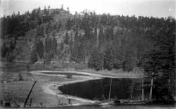
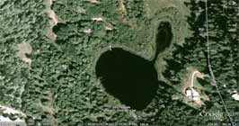
Usha recognized this scene as Robertson Lake. |
| Laurie Goodman thinks: Roberts Lake with Mount Belcher in the background. The photo was taken at about noon, since the shadows under the trees are short. | 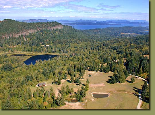 |
another twist?
Dad(Ed Marcott) thinks it is the man made lake on Mt. Bruce. He doesn't know the name but it was used to hold the logs for the sawmill.
I wonder what direction that view is of Roberts Lake? And where is that road? Is that Cranberry road? I've never seen sand on the shores of Roberts Lake. It's all marsh and bog, and all the edges are thick with reeds and lilly pads.
Peter.
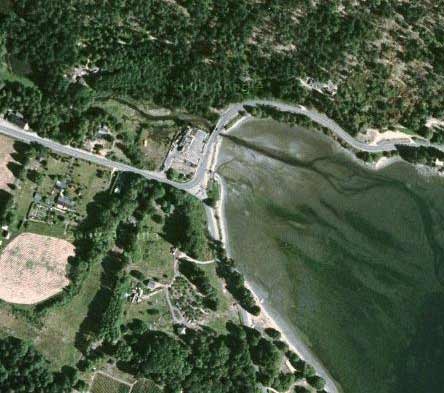
yeah i was wondering the same...looks like Roberts lake from the aerial photo but i was originally thinking the head of Fulford Harbour (the real "Wenannec" a reference to the extra lagoon orignally at the head of the harbour since covered by publican houses? Chris
Yes, the shore has the tell tale signs of of tidal action. When looking north from Drummond Park, above the Fulford Inn, see how steeply the ground rises from the water and roadway. And the profile of that hilltop, although it's much more heavily treed now, it resembles the hilltop in the photo. And yes at harbour's end, Fulford Creek becomes a lagoon behind the Fulford Inn, and at high tide you can paddle under the bridge and right up beside the Inn.
Back in the day, it would have been a beautiful necessity, a protected zone, a place for Salish canoes and people to find shelter from East winds, wave action and offering fresh water...probably why they built the Inn there!
My 2-cents.
P.
With benefit of aerial, looks like Roberts. 'Lake's'green to' brown seasonal cycle suggests photo was taken in dry season. But the hilltop and the distance from road to water seem different. Sure looks like the hill behind Fulford Inn.
Earth changes since photo was taken? Joking of course. Contour map might help. Is it Bullock Lake? The idea of having a cedar rail fence going down to shoreline in Fulford maybe the most telling feature. I don't believe they had cattle grazing down to the shoreline by the sea, more likely by a lake. Or is it a property line fence then? But why put a divide in the land at that spot there in the Fulford harbour? Now I'm leaning toward lake, which was my first thought when I saw the photoÊat Frank's,Êand noticed the cedar rail fence in it. During the era that Jesse Bond was taking photos round SaltSpring, that corner of Fulford Harbour was already quite established with road, bridge and other nearby buildings. Wasn't it?
Peter
I love this puzzle!
I'm not ruling out the head of Fulford Harbour, just recording my instant recognition of the shape of the water, and the lie of the road beyond.
I think Frank told me the lie of the hillside beyond in the B&W photo had been "tested" and fits with Fulford Harbour?
Maybe if I feel very athletic I could walk up the Cranberry and look right instead of left as I tend to do (when driven, and whizzing past).
I think the lie of the hillside might prove the deciding factor.
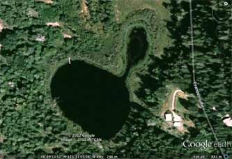
I recognised the lake immediately by its shape "No other lake has the shape of Roberts Lake (used to be Allen's Lake) - the thin bit between the little pond-lake and the larger oval with that dead-straight side 'ponds'"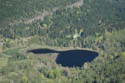
The road you see in the b&w photograph just above the far side of the lake is the Cranberry.
Frank figured out via Google Earth (see the pic he sent - hopefully successfullyattached by me below) that the viewpoint of the photographer was pretty much in line with the white rectangle that seems to be a dock - there is a house site to the bottom left of the dock.
However, I think one might need to be further bak and a little higher up - but that also depends on the lens used in the camera, which can also give than effect.
The B&W photo is old, and looks to me to be when the land was recently cleared all around the lake (not admissable today, for the health of the entire watershed RobertsLake-BlackburnLake-CusheonLake-CusheonCreek to the outlet). I live in this watershed, and know the look of the three lakes from above - from the top of Mt Belcher.
 Re "the tell tale signs of of tidal action", living beside Blackburn Lake I can assure you it leaves tell-tale signs of Mt Maxwell snowmelt season and heavy rainstorms - we live in what they call a micro-climate zone that extends the spread of Robert Lake and Blackburn mightily. You can see in the aerial photo above the full extent of the regular flood level, by the bright green crescent to the left (at Blackburn, the lower reaches of the golf course are completely covered by water at times, so the lake looks much closer to me, and so very much vasterer).
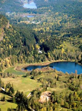 Aha, I have found the view of the watershed from the top of Mt Belcher, showing the succession of lakes - Roberts Lake below you, Blackburn looking tiny, and Cusheon beyond (at the top of the photo):
There you can also see the reedy shore (brown season) and the perpetually bright green flood crescent, and the point-of-view of the old B&W photo.
However, as I suspected, the lie of the hillside beyond, as seen from above, anyway, does not look to me at all like the Divide Ridge I know so well!
I cannot believe there's be that dip to the left seen in the B&W old photo - you'd surely see a steady rise (as you can see in the watershed photo, that high vertical cliff-edge that runs all along behind me, and on above Cusheon Lake, which divided the south end from the north end so effectively until Rock-Crusher corner was cut through to replace the arduous verticality of the Old Divide Road, or the long hard grind of the endless sideways rise of the first trail through to the Cranberry from the south.
I might resort to studying a detailed contour map rather than going for a long hike to find out.
The Lagoonies might well win against the Lakers.
But what FUN, if the lagoon at the head of Fulford Harbour were so much like Roberts Lake! I'd expect a cosmic Coast Salish tale to account for something going on there to account for such a stunning similarity ...
I'm eager to prove you right!
 Peter and Chris, I do hope that a 2.9MB email does not screw up your computers.
I just felt having all the pics together would help.
And I just had to add a Google Earth of the head of Fulford Harbour:
Usha