| click on map to enlarge |
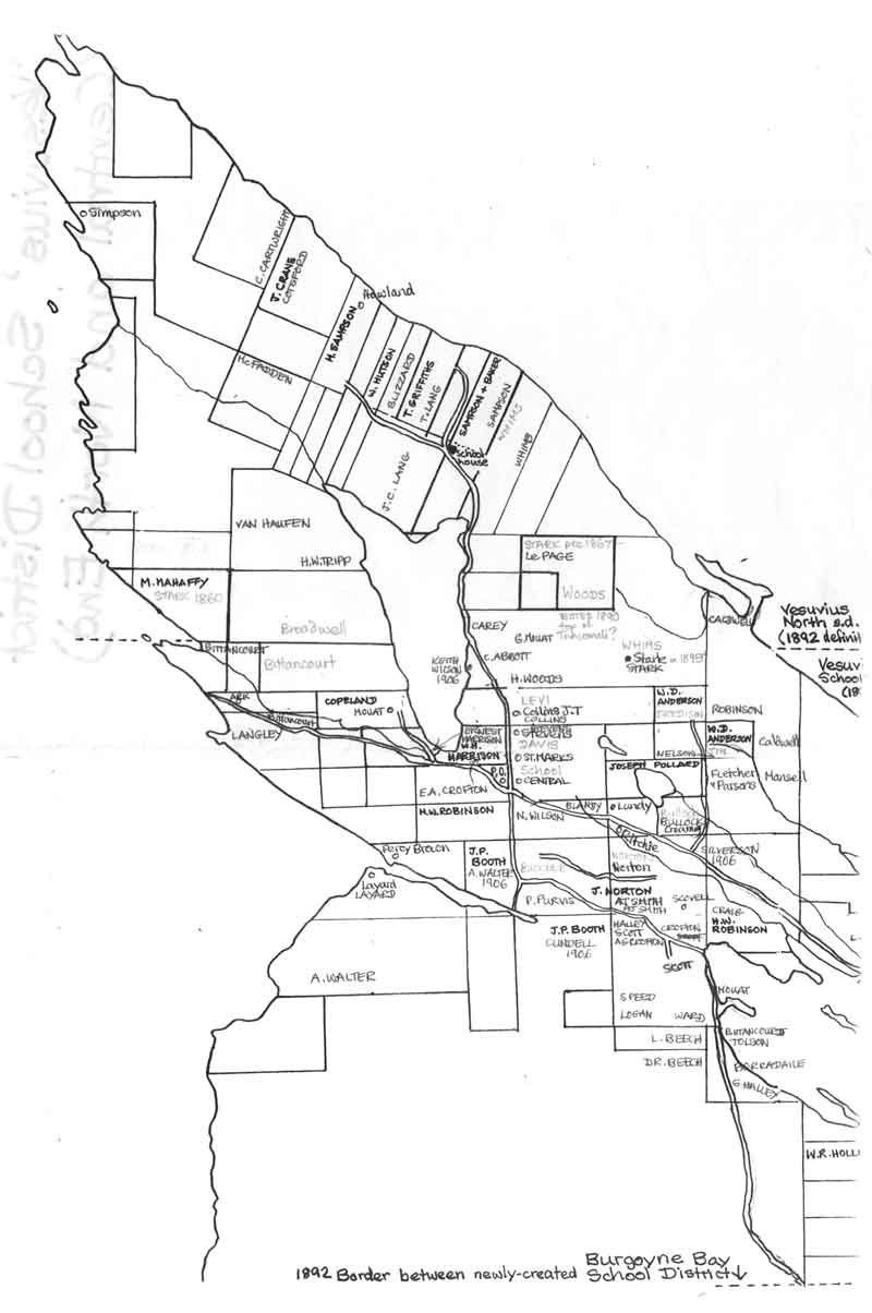
These are Usha's maps, trying to establish the various early communities of Salt Spring's pioneers, (to find out about the communities that grew up to establish the first schools, one by one in different areas of the Island).
These are the property boundaries surveyed in 1874-1875 and still in existence today.
I was using the names written by Ashdown Green onto his survey map 1874 (south end) and 1875 (north end), and correlating this, where at all possible, with the family names on the 1912 map in the museum (and in Charles "Story Of An Island"), and the family names on a collection of tourist maps of Salt Spring (without the property boundaries) on which the descendants of pioneers were writing the names of families known to live, roughly speaking where they wrote their names - I hadn't gone through all those collections, because they were being made at the time I was doing what I was doing.
Then I was double-checking the pioneer descendant maps again with the census records, assuming, but not with certainty, just hopeful supposition, that the census taker was moving from house to house through a neighbourhood, so the numbered households might be neighbours, roughly speaking - I was a little obsessive! I also talked with some people to double-check. I also began checking the crown grant numbers, but I didn't get far enough into that before I stopped - probably because Ruth Sandwell had done that, so we could eventually get that once her book was published, etc. (I was doing this research after she had completed her research, but while she was writing it up)
As far as I can remember:
- the dark black lines (and names in capitals) are my drawing (meticulously accurate) of the 1874 survey map, and transcription of the owner names that Ashdown Green wrote onto some of the properties.
- there are hesitant pale pencilled names - these come from the descendants' maps
- there are more surely mid-grey names in upper case - these are the names I was pretty sure of having located correctly, from various sources - including, of course, the names of the roads
- pencilled notes probably still exist in my house somewhere detailing all my sources
Looking at it now, I can see I know more names of pioneer property owners than is recorded on these maps - I did this series of maps back in the 20th Century.
Usha
![]()